Management
World heritage Site Management
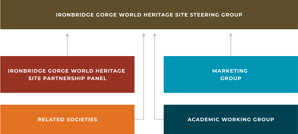
Ironbridge Gorge World Heritage Site Governance
Here you will find information about the Ironbridge Gorge World Heritage Site governance, including how the site is managed and information about the various partnerships and groups involved.
Steering Group
The Ironbridge Gorge World Heritage Site Steering Group was established in 1995 and is a strategic body comprising senior professional and community representatives from key stakeholders, see the full list below.
The Steering Group meets biannually to undertake two key responsibilities.
- To monitor the management plan implementation.
- To coordinate World Heritage Site working groups.
Partnership Panel
The panel includes the four key partners; Telford & Wrekin Council, National Trust, Severn Gorge Countryside Trust, and the Steering Group Chair. The four partners meet once a month to handle any immediate issues between Steering Group sessions.
Working Groups
Various working groups are being sought to feed into the management and understanding of the Ironbridge Gorge World Heritage Site.
Currently the areas being sought are for the following:
- Research
- Related Societies
- Marketing.
The Working Groups would meet once or twice a year (depending on the needs or wishes of the group) to feed information into the Steering Group. If interested or you would like more information please get in touch: [email protected].
How it works
Management plan
It is UNESCO and UK Government policy that all UK World Heritage Sites should have management plans. The production of the Ironbridge Gorge World Heritage Site Management Plan is overseen and administered by the Ironbridge Gorge World Heritage Site Steering Group.
The Ironbridge Gorge is one of Britain’s first World Heritage Sites, inscribed onto the United Nations Educational, Scientific and Cultural Organisation (UNESCO) World Heritage List in 1986. The Ironbridge Gorge is of universal significance for its unimue role in the development of the Industrial Revolution that largely originated in Britain in the eighteenth century and later
spread across the world.
Within the World Heritage Site (WHS) are substantial remains of furnaces, works, dwellings and transport systems together with extensive collections of artefacts and archives relating to the individuals, communities, processes and products that made this area so important.
At the heart of the WHS stands the great Iron Bridge, the world’s first bridge constructed of iron that has become a universal symbol of the Industrial Revolution. The Management Plan represents a consensual view of the members of the Ironbridge Gorge World Heritage Site Steering Group, following consultation with the local community and relevant organisations and agencies.
- Introduction
1.1 UNESCO and World Heritage Sites
The United Nations Educational, Scientific and Cultural Organization (UNESCO) seeks to encourage the identification, protection and preservation of cultural and natural heritage around the world considered to be of outstanding value to humanity. This is embodied in an international treaty called the Convention concerning the Protection of the World Cultural and Natural Heritage, adopted by UNESCO in 1972.
UNESCO’s World Heritage Mission is to:
- Help States Parties safeguard World Heritage properties by providing technical assistance and professional training;
- Provide emergency assistance for World Heritage sites in immediate danger;
- Support States Parties’ public awareness-building activities for World Heritage conservation;
- Encourage participation of the local population in the preservation of their cultural and natural heritage;
- Encourage international cooperation in the conservation of our world’s cultural and natural heritage.
- Encourage countries to sign the World Heritage Convention and to ensure the protection of their natural and cultural heritage;
- Encourage States Parties to the Convention to nominate sites within their national territory for inclusion on the World Heritage List;
- Encourage States Parties to establish management plans and set up reporting systems on the state of conservation of their World Heritage sites;
The UNESCO World Heritage Committee works with a set of Operational Guidelines for the Implementation of the World Heritage Convention (July 2015)1. These Guidelines aim to facilitate the implementation of the Convention concerning the Protection of the World Cultural and Natural Heritage, by setting forth the procedure for:
- the inscription of properties on the World Heritage List and the List of World Heritage in Danger;
- the protection and conservation of World Heritage properties;
- the granting of International Assistance under the World Heritage Fund; and
- the mobilization of national and international support in favour of the Convention.
World Heritage Site (WHS) designation is for properties, sites and landscapes, cultural, natural and ‘mixed’, that embody the concept of ‘Outstanding Universal Value’ (OUV) and recognised by UNESCO as having common importance for the present and future generations of all humanity and therefore in need of protection. The concept of World Heritage is at the core of the World Heritage Convention. The Convention came into effect in 19722 and the World Heritage List was established in 1978. In 2015, there are 1,031 properties3 (802 cultural, 197 natural, and 32 mixed properties), which form the cultural and natural heritage that the World Heritage Committee considers as having outstanding universal value (UNESCO, 2014).
Inscription on the World Heritage List by the World Heritage Committee of UNESCO does not confer any additional legal protection but it does convey a significant international prestige that cannot be understated. Moreover, by nominating a site for inscribing on the World Heritage List, national governments are explicitly stating their commitment to the conservation and protection of the site in situ in perpetuity.
1.2 World Heritage Sites in the UK
The United Kingdom ratified the World Heritage Convention in 1984 and submitted its initial list of World Heritage Sites in 1986, which included Stonehenge, Durham Castle and Cathedral, Giant’s Causeway, and the Ironbridge Gorge. As of 2015, there are 29 World Heritage Sites in the United Kingdom (23 cultural, 4 natural, and 1 mixed). The UK Department for Culture, Media and Sport (DCMS) submits nominations to UNESCO World Heritage Centre who forward them to the International Council on Monuments and Sites (ICOMOS) after consulting with its primary heritage management agency, Historic England (DCMS, 2014).
The National Planning Policy Framework recognises the importance of conserving and enhancing the historic environment. It specifically refers to World Heritage Sites as a designated heritage asset of the highest significance and provides policy direction regarding development within a WHS and the need for local planning authorities to make information publicly available regarding the significance of a WHS within their area.
1.3 Background
The Ironbridge Gorge World Heritage Site was inscribed as a World Heritage Site in 1986. At the time of its inscription, UNESCO did not require submittal of management plans of World Heritage Sites although Article 29 of the World Heritage Convention required that States’ parties submit reports as attachments on both legislative and administrative provisions for the application of the Convention to their WHS’s. The Twenty-ninth General Conference of UNESCO activated Operational Guidelines for WHS’s in 1997 (Ringbeck, 2008). Telford and Wrekin Council produced the first Ironbridge Gorge World Heritage Site Management Plan in 2001 and updated it in 2010.
1.4 The Purpose of the Management Plan
The Operational Guidelines for the Implementation of the World Heritage Convention (July 2012) note that management systems may vary according to different cultural perspectives and resources and also the type and characteristics of the nominated property (para.110)
The Guidelines state:
Each nominated property should have an appropriate management plan or other documented management system, which must specify how the OUV of a property should be preserved, preferably though participatory means.
The purpose of such a management system is to ensure the effective protection of the site for future generations (paras.108 -109).
Since 1994 it has been UK Government policy that all UK World Heritage Sites should have Management Plans. The Historic England Guidance Note The Protection & Management of World Heritage Sites in England (para 5.2) recommends:
- Each World Heritage Site should have an agreed Management Plan
- Regional and local authority commitment to the protection, promotion and management of World Heritage Sites in their area.
- A stakeholder steering group and support from the key partners, including major owners, managers and communities.
- Effective co-ordination, normally by a dedicated co-ordinator.
This guidance note also includes three other key elements;
- Designation of specific assets within WHS’s (Listed Buildings, Conservation Areas, Scheduled Monuments etc.)
- WHSs are a key material consideration in the determination of planning applications.
- Planning Authorities should include policies in their local plan to protect the OUV, authenticity and integrity of WHSs.
These are relevant as Management Plans are mentioned within Local Plan policies.
The purpose of the Management Plan (Plan) is to ensure the preservation and protection of the Outstanding Universal Value of the Ironbridge World Heritage Site; this includes the significant monuments, the archaeological sites and the historic buildings and sites, all within a historic and accessible landscape. The Plan also aims to improve the interpretation and understanding of the cultural landscape to its visitors and inhabitants and enhance the living community within the WHS through social and economic regeneration. Social interaction, among both visitors and inhabitants and cultural and ecological stewardship is promoted throughout the Plan. Continuing research into the origins and history of the Ironbridge WHS will inform appropriate future management of the site.
Since its designation, the Ironbridge Gorge World Heritage Site has been a popular tourist destination. For over thirty years, the WHS has been managed to ensure the preservation of its unique character and Outstanding Universal Value. In this current Plan, important ideas pertaining to developmental, environmental and cultural sustainability have been incorporated. It provides a mechanism for an agreed framework among all of the stakeholders and partners within the Ironbridge Gorge for long-term and holistic decision making to enable the conservation, improvement, development and interpretation of the Ironbridge Gorge World Heritage Site.
Once approved by Historic England, management plans are forwarded to UNESCO and ICOMOS for review (English Heritage and DCMS, 2014).
1.5 Ironbridge Gorge World Heritage Site Management Plan -Vision Statement
The Ironbridge Gorge is rich in the material evidence of Britain’s emergence as the world’s first industrial nation. The events that took place here were fundamental to the origins of the Industrial Revolution and all that arose from it. Its significance is unquestionably global.
Today the genius of the place lies in its fusion of early industry, the fabric of the community that has grown up around it, and dramatic topography softened by a mosaic of post-industrial woodland habitats. This landscape is at once precious and fragile, home to a vibrant community, and a place for visitors who seek to understand its role in the making of the modern world and to simply enjoy its dramatic beauty.
This management plan sets out to reconcile the voices of the past with ambitions for today and tomorrow. It identifies the qualities that distinguish this most cherished of places, and proposes how the Gorge can be nurtured so that future generations may value and enjoy all it has to offer. Above all, it demands that we treat the Ironbridge Gorge with the most thoughtful attention and detailed care.
To these ends, partners in the Ironbridge Gorge are committed to working together to:
- Safeguard the unique industrial heritage and character of the Ironbridge Gorge World Heritage Site for present and future generations.
- Strengthen the World Heritage Site as a vibrant living and working community and strong economy.
- Interpret the World Heritage Site in ways that ensure its accessibility to all.
- Incorporate holistic planning and strategic decision-making which will conserve the historic environment, essential ecological processes and biodiversity found in the Ironbridge Gorge World Heritage Site.
1.6 The Preparation and Structure of the Management Plan
This Plan (2017) is the revision of the 2008 Plan. For details of the results achieved against the 2008 Plan see Appendix A.
Telford & Wrekin Council, as the managing authority of the WHS, has commissioned the Ironbridge Gorge Museum Trust, as part of a 10 year Service Level Agreement, to lead on the preparation of the Plan. This work has been overseen by the Ironbridge Gorge World Heritage Site Steering Group (for membership and terms of reference see Appendix B) and has included public consultation with the local community and with national bodies.
The new Plan is broken down into 4 parts covering; A: why the Ironbridge Gorge is internationally important and descriptive details of the significance of the Site, B: an assessment of the issues and challenges affecting the Site together with the opportunities and objectives to overcome these, C: the management of the Site, and finally D: a section detailing how the actions will be implemented, monitored and evaluated.
1.7 Planning Context of the Management Plan
1.7.1 Overview
The UK has a highly developed and comprehensive system of land use planning and management of environmental and cultural preservation, including the protection of archaeological, architectural, historic, cultural, landscape and ecological importance. This system includes formal listing of historic buildings, objects, and sites and designation of Conservation Areas, Scheduled Monuments, and Tree Preservation Orders. The UK planning systems is hierarchically structured consisting of national planning policies supported by regional and local policies.
1.7.2 National Planning Policy Framework (NPPF) and Planning Practice Guidance (PPG)
The National Planning Policy Framework was published on 27 March 20124 and sets out the Government’s planning policies for England and how these are expected to be applied.
The NPPF is supported by the PPG5 which provides guidance on how the policies in the NPPF should be applied.
These two documents provide the framework and the guidance for local planning authorities and decision-takers regarding the production of Local Plans and for making decisions about planning applications.
Section 12 of the NPPF covers the conservation and enhancement of the historic environment and paragraphs 128 to 141 set out the way in which planning applications affecting heritage assets should be assessed and determined. Paragraph 126 deals with the preparation of Local Plans. The PPG supports the NPPF, by providing additional guidance on planning implications within World Heritage Sites setting out their importance, and the need to develop a positive approach to conservation and the enjoyment of World Heritage Sites.
Policy frameworks at all levels should conserve the OUV, integrity and authenticity of the WHS and its setting. Appropriate policies for the protection and sustainable use of the WHS, including enhancement where appropriate, should be included in relevant plans. These policies should take account of international and national requirements as well as specific local circumstances.
1.7.3 Local Planning Policy
The World Heritage Site lies within two Local Authority areas (Telford & Wrekin Council and Shropshire Council) and as such it is affected by local planning policies from each authority.
Telford & Wrekin Council
The two existing Telford & Wrekin Local Planning documents, which are most relevant to the World Heritage Site, comprise the saved policies of the Wrekin Local Plan (1995- 2006) and the Core Strategy (2007- 2016).
Whilst it is important to consider the implications of all policies in the Wrekin Local Plan, especially those relating to built and natural environment, the plan specifically contains a section dedicated to the Ironbridge Gorge World Heritage Site containing 13 policies, 8 of which have been saved.
The Core Strategy contains a number of policies which have implications for the IGWHS but those relating to the Natural Environment (Policy CS12), Cultural, Historic and Built Environment (Policy CS14) and Urban Design (Policy CS15) are especially relevant.
At the time of writing, Telford & Wrekin Council has prepared a new Local Plan (Publication version January 2016), which will replace both the saved policies of the Wrekin Local Plan and the Core Strategy. The intention is that this Local Plan will be adopted in Spring 2017.
The Telford & Wrekin Local Plan is based upon the following principles:
The document also specifies an area based Supplementary Planning Document will be produced for the World Heritage Site.
Shropshire Council
The Shropshire Local Plan comprises the Core Strategy 2006 – 2026 and the Site Allocations and Management of Development (SAMDev) Plan. Together these documents contain a number of policies which are relevant to the World Heritage Site. Within the Core Strategy they comprise Policy CS3 (The Market Towns and other key centres), Policy CS6 (Sustainable Design and Development); Policy CS16 (Tourism, Culture and Leisure), and Policy CS17 (Environmental Networks). These are further supplemented by the development management policies in SAMDev, which comprise Policy S4 (Broseley), MD12 (Natural Environment) and MD13 (Historic Environment).
SAMDev policies MD12 and MD13 will be supported by two Supplementary Planning Documents (SPDs) on both the natural and the historic environment.
These will set out what level of information will be required to support a planning application which will potentially affect the natural environment and the significance of heritage assets, including the World Heritage Site, and provide relevant links to appropriate national and local guidance.
Together, these policies and SPDs will enable the same principles that will lie behind the Telford & Wrekin Local Plan to be upheld by Shropshire Council.
Madeley Town Council
Madeley Neighbourhood Plan was made in March 2015 and sits alongside Telford & Wrekin’s strategic planning policy and helps decide the outcome of planning applications. The protection and enhancement of our local heritage was a key component of this Plan.
There was major concern about how the local character of the area was being eroded through insensitive changes. The plan allowed the Conservation area to be sub divided into 4 sub areas and a criteria based policy was tailored for each sub-area.
- Description of the Ironbridge Gorge World Heritage Site
2.1 A Brief History
The name Ironbridge Gorge is used throughout the Management Plan. The name of the WHS is derived from the iconic structure - the Iron Bridge, which was built in 1779. When the Bridge was built it was immediately recognised as the first iron bridge in the world. Visitors from across the UK and from other countries came to Shropshire to admire its ingenuity. The WHS lies within the southern end of the East Shropshire coalfield within a gorge formed by a glacial overflow that occurred during the ice ages. The coalfield is exceptionally rich in mineral resources; along with deposits of coal, the land area has significant deposits of carboniferous limestone, iron ore, and clays suitable for making brick, roofing tiles decorative tiles, pottery, and tobacco pipes. The natural resources extracted throughout the area allowed the Industrial Revolution to emerge in England. The River Severn flows predominately west to east through the Ironbridge Gorge; it was the principal route for transporting products produced in the area for customers from across the world during the 18th century.
The WHS is comprised of five communities - Coalbrookdale, Ironbridge, Coalport, Jackfield and parts of the community of Madeley. These communities began in the seventeenth century with the exception of Ironbridge, which was established in the eighteenth century after the construction of the Iron Bridge. The pattern of settlement in much of the Ironbridge Gorge is informal in nature. This is due in part to the weak manorial control that occurred during the seventeenth century; migrants to the Gorge tended to squat on common land or build cottages on waste areas. Many residential lots are irregularly shaped and linked by pathways and steps that ran between the riverbanks and the hillside mines. In Coalbrookdale and Coalport, there are more formal terraces, which were built as part of larger residences by employers. In the 18th century, more formal town development occurred at the northern end at Ironbridge; this reflected the ambitions of the bridge builders and the economic prosperity that they achieved. These varied aspects of local distinctiveness need to be recognised, respected and conserved whenever plans are drawn up and decisions made about change.
Other settlements such as parts of Madeley and the town of Broseley, that fall outside of the immediate boundary of the WHS, have contextual importance to the WHS with a history of early industrialisation from the 16th century and earlier and are dynamically connected to the area as a whole.
2.2 Statement of Outstanding Universal Value
2.2.1 Brief Synthesis
The Ironbridge Gorge World Heritage property covers an area of 5.5 km2 (550ha) and is located in Telford, Shropshire, approximately 50km north-west of Birmingham. The Industrial Revolution had its 18th century roots in the Ironbridge Gorge and spread world-wide leading to some of the most far-reaching changes in human history.
The site incorporates a 5km length of the steep-sided, mineral-rich Severn Valley from a point immediately west of Ironbridge downstream to Coalport, together with two smaller river valleys extending northwards to Coalbrookdale and Madeley.
The Ironbridge Gorge provided the raw materials that revolutionised industrial processes and offers a powerful insight into the origins of the Industrial Revolution. It contains extensive evidence and remains of that period when the area was the focus of international attention from artists, engineers, and writers. The site contains substantial remains of mines, pit mounds, spoil heaps, foundries, factories, workshops, warehouses, iron masters’ and workers’ housing, public buildings, infrastructure, and transport systems, together with traditional landscape and forests of the Severn Gorge. In addition, there also remain extensive collections of artefacts and archives relating to the individuals, processes and products that made the area so important.
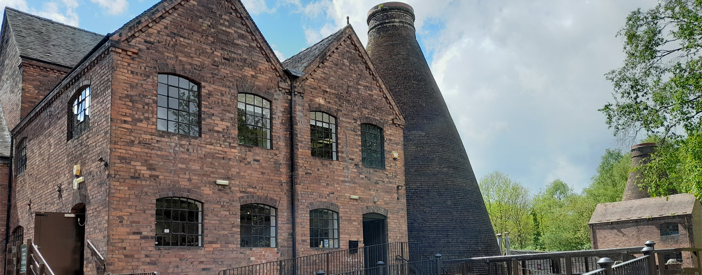
Today, the site is a living, working community with a population of approximately 4,000 people and is a world renowned place to visit. It is also a historic landscape that is interpreted and made accessible through the work of a number of organisations, in particular, the Ironbridge Gorge Museum Trust (established in 1967 to preserve and interpret the remains of the Industrial Revolution within the Ironbridge Gorge) and the Severn Gorge Countryside Trust (established in 1991 to manage the woodland and grassland and associated historic structures in the Gorge).
Within the site, five features are highlighted as of particular interest:
It was in Coalbrookdale in 1709 that the Quaker Abraham Darby I developed the production technique of smelting iron with coke, which began the great 18th century iron revolution. There still remains a high concentration of 18th and 19th century dwellings, warehouses and public buildings in Coalbrookdale.
In Ironbridge, the community draws its name from the famous Iron Bridge erected in 1779 by Abraham Darby III. At the eastern end of Ironbridge stand the remains of two 18th century blast furnaces, the Bedlam Furnaces, built in 1757. In Hay Brook Valley, south of Madeley, lies a large open-air museum, which incorporates the remains of the former Blists Hill blast furnaces and Blists Hill brick and tile works. Also of importance is the spectacular Hay Inclined Plane, which connected the Shropshire Canal to the Coalport Canal, which in turn linked with the River Severn. The small community of Jackfield on the south bank of the River Severn was important for navigation, coal mining, clay production, and the manufacture of decorative tiles. Located at the eastern end of the property and on the north bank of the River Severn, industrialisation came to Coalport in the late 18th century and the area is remembered principally for the Coalport China Works.
Criterion (i):
Represent a unique artistic achievement, a masterpiece of human creative genius.
The Coalbrookdale blast furnace perpetuates in situ the creative effort of Abraham Darby I who discovered the production technique of smelting iron using coke instead of charcoal in 1709. It is a masterpiece of man’s creative genius in the same way as the Iron Bridge, which is the first known metal bridge. It was built in 1779 by Abraham Darby III from the drawings of the architect Thomas Farnolls Pritchard.
Criterion (ii):
Have exerted great influence over a span of time or within a cultural area of the
world, on developments in architecture, monumental arts, or town planning and
landscape.
The Coalbrookdale blast furnace and the Iron Bridge exerted great influence on the development of techniques and architecture.
Criterion (iv):
Be an outstanding example of a type or building or architectural ensemble which
illustrates a significant stage in history.
Ironbridge Gorge provides a fascinating summary of the development of an industrial region in modern times. Mining centres, transformation industries, manufacturing plants, workers’ quarters, and transport networks are sufficiently well preserved to make up a coherent ensemble whose educational potential is considerable.
Criterion (vi):
Be directly or tangibly associated with events or ideas or beliefs of outstanding
universal significance
Ironbridge Gorge, which opens its doors to an estimated one million visitors yearly, is a world renowned symbol of the 18th century Industrial Revolution.
2.2.2. Integrity
The boundary of the property is clearly defined by the steep sided Gorge and encompasses an extraordinary concentration of mining zones, foundries, factories, workshops and warehouses which coexist with the old network of lanes, paths, roads, ramps, canals and railroads as well as substantial remains of traditional landscape and housing. The ironmasters’ houses, the workers’ living quarters, public buildings and infrastructure are all within the five identifiable areas of Coalbrookdale, Ironbridge, Hay Brook Valley with Madeley, Jackfield and Coalport, which are enclosed by a common boundary. The well preserved historic fabric is well supported by detailed historic archives and collections of manufactured goods. The technologically revolutionary Iron Bridge spanning the River Severn Gorge is the focal point of the property and, together with the attributes above, includes all that is necessary to convey the former pioneering intense industrial past within its green landscape and thus the Outstanding Universal Value of the property.
None of the key industrial attributes are under threat, but the overall mining landscape is vulnerable to land instability resulting from mining, underlying geology and incremental changes, which over time could impact the character of the valley. The landscape is a crucial part of the property, and it needs to be managed as a coherent whole, with significant views across the valley identified and protected.
2.2.3 Authenticity
The decline of the industries and the prosperity of the area at the end of the 19th and start of the 20th centuries in a way helped to protect most of the urban fabric within the property and its landscape. The different types of dwellings, industrial buildings and structures did suffer from a degree of neglect following the decline in prosperity. However, in recognition of the area’s unique industrial heritage significant late 20th century investment reversed this decline. With careful attention to details, materials and techniques, most of the historic buildings, structures and urban and rural patterns have retained their essential and authentic historic character, although, some industrial monuments await conservation work.
In 2010, an estimated one million people visited the Ironbridge Gorge and its museums. The Victorian Town Open Air museum at Blists Hill was established before inscription and incorporates scheduled industrial monuments, reconstructed 19th century buildings and new buildings based on local examples. Care is taken to ensure that the relationship between the original buildings and monuments on the property and the other structures, which do not form part of the historic attributes of the property is clearly stated ensuring authenticity is not compromised.
2.2.4 Protection and Management Requirements
The UK Government protects World Heritage properties in England in two ways. Firstly, individual buildings, monuments, gardens and landscapes are designated under the Planning (Listed Buildings and Conservation Areas) Act 1990 and the 1979 Ancient Monuments and Archaeological Areas Act and secondly, through the UK Spatial Planning System under the provisions of the Town and Country Planning Acts.
Government guidance on protecting the Historic Environment and World Heritage is set out in the National Planning Policy Framework and Circular 07/0911. Policies to protect, promote, conserve and enhance World Heritage properties, their settings and buffer zones are also found in statutory planning documents. World Heritage status is a key material consideration when planning applications are considered by the Local Planning Authority. The Telford & Wrekin Core Strategy contains policies to protect the property. This Strategy is replaced by a Local Plan covering a period of approximately 25 years.
The property lies predominantly in the boundary of Telford & Wrekin Council with a small south-east portion within the Shropshire Council boundary. The entire site is a designated Conservation Area and there are over 375 listed buildings of which two are Grade 1 and eighteen are Grade 2*. In addition, there are 7 Scheduled Ancient Monuments. There are two Sites of Special Scientific Interest within the World Heritage property.
Added control over changes to the property is achieved through an Article 4(2) Directive for the Conservation Area12, which withdraws permitted rights for certain development. Additional controls under a wider Article 4(2) Directive were implemented in 2015 as an improved management tool to prevent damaging incremental change.
The Ironbridge Gorge World Heritage Site Management Plan is under regular review every ten years. Boundaries and protection mechanisms are reviewed as part of the management plan process. The delivery of the management plan will be implemented by all partners, in conjunction with Telford & Wrekin Council and overseen by a World Heritage Site Steering Committee by which the key stakeholders are represented. The day to day management activities are carried out at local level by Telford & Wrekin Council together with diverse organisations, agencies, and owners who have various management responsibilities within the property.
There is a need to ensure that management of the property covers the whole area within the boundaries, including the rich ensemble of minor buildings and the encompassing landscape that together give the major structures such as the Iron Bridge and the Old Furnace at Coalbrookdale their extraordinary social and economic context. The Management Plan review looks at ways this can be achieved. Land instability resulting from previous mining activity and underlying geology is a significant factor in the Gorge and some stabilisation has taken place. A comprehensive, holistic management approach is required and further works are likely to be planned, as funding becomes available, as part of a major phased stabilisation programme. An Environmental Impact Assessment, including heritage assessment, will be undertaken to inform the design process.
There is also a need to promote wider understanding of the scope and extent of the property and its inter-related attributes. A visitor and interpretation centre enables visitors to understand the geographical and geological context to the property and visitors are encouraged to visit the various museums and villages and to walk along the river and the slopes of the Gorge.
Additional visitor facilities include improving the Destination offer as a whole with transport links such as the Park and Ride facility and rail connectivity, and upgrading visitor accommodation being important in this. This complements the comprehensive high quality interpretation and education service provided by the ten Ironbridge Museums and the Ironbridge Institute.
2.3 General Information
- Location
Name: Ironbridge Gorge
Location: England, within the United Kingdom
Region: West Midlands
Local authorities: Telford & Wrekin Council and Shropshire Council
Parishes: The Gorge, Madeley and Broseley
Geographical coordinates: National Grid Reference: (The Iron Bridge) SJ 672034 Longitude: 2° 29’ W Latitude: 52° 37’ N
Date of inscription: 1986
The Ironbridge Gorge Today
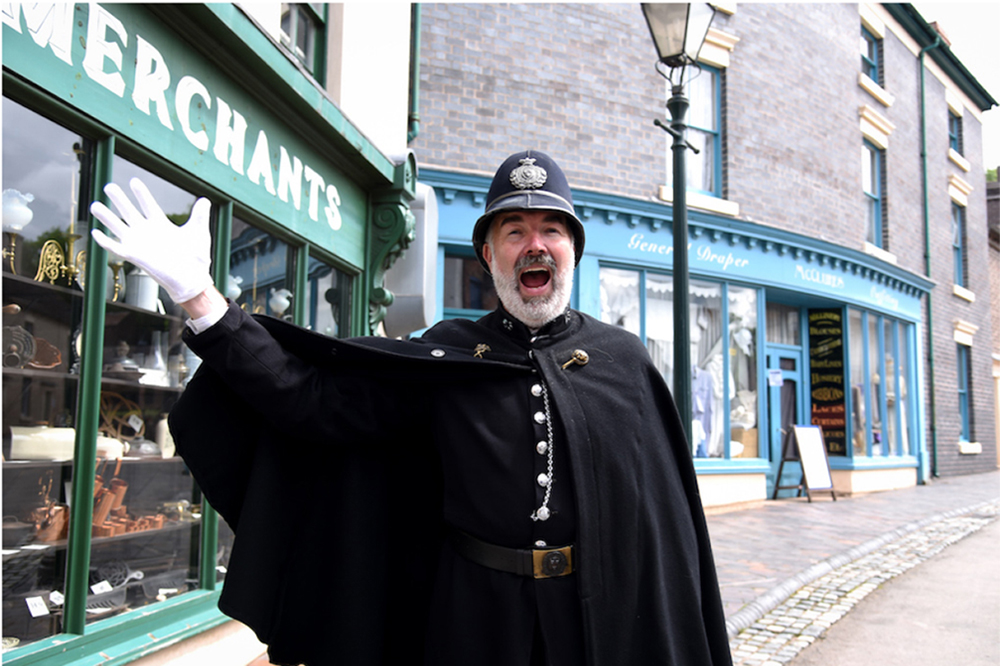
The Ironbridge Gorge World Heritage Site is considered one of the most successful heritage destinations in the world. With an estimated one million visitors a year, it is one of the most popular tourism destinations in the West Midlands. Visitors experience and enjoy the 10 world-class museums that celebrate the role of the Gorge as one of the birthplaces of the Industrial Revolution, as well as the natural landscape, the iconic Iron Bridge and the town of Ironbridge itself.
The town of Ironbridge and its surrounds is home to numerous independent shops, cafés, pubs, small hotels and bed and breakfasts, presenting an attractive offer to tourists and local residents. Madeley Town Centre is the focus for retail activity (including Tescos and Aldi foodstores together with independent retailers) as well as for financial and professional services, restaurants, pubs and hot food takeaways. Throughout the Gorge, people have renovated historic residences and churches, restoring their former character. Manufacturing remains within the Ironbridge Gorge; oven and cooking range manufacturer, Aga-Rayburn, began their operations in Coalbrookdale, adjacent to the historic Darby furnace in 1946. They continue the iron and metal working tradition in the Gorge. The most interesting fusion of industrial heritage and the continuation of industry can be found in Jackfield where Craven Dunnill Jackfield, Ltd. brought architectural decorative tile manufacturing back to the Gorge within the walls of the original Craven Dunnill Encaustic Tile Works, now the Jackfield Tile Museum. The Ironbridge Gorge has always been a centre for innovation and it remains so today.
- Boundaries and Buffer Zones
The boundaries of the Ironbridge World Heritage Site enclose an area of approximately 550 hectares, which coincide with the boundaries of the Severn Gorge Conservation Area (formerly designated in 1980) in Telford, Shropshire. The site incorporates a 5km length of the steep-sided, mineral-rich Severn Valley from a point immediately west of Ironbridge downstream to Coalport, together with two smaller river valleys extending northward to Coalbrookdale and Madeley. The boundaries of the WHS end at the north section of Coalbrookdale.
As part of the completion of this Plan a review of the boundary of the WHS was undertaken at the northern and western edges within the Madeley parish and also on its southern edge in Broseley. These areas, together with other historic coalfield settlements in the vicinity, carry undoubted significance in their own right (as laid out in proposals put forward by the Town Councils of Madeley and Broseley to the Ironbridge Gorge World Heritage Site Steering Group in 2014), as well as in forming the supportive context for the Ironbridge Gorge itself. Following this review, and after careful consideration, there are no changes recommended to the existing boundary of the Ironbridge Gorge WHS, and no buffer zones are proposed.
2.4 The Character of the WHS in its Setting
2.4.1 Overview
The Ironbridge Gorge consists of two steep wooded valleys and a Gorge cut by the River Severn, which has dictated development. It is a geologically unstable environment that is also prone to flooding and so development over many years has had to cope and adapt to these factors.
The Ironbridge Gorge can be best characterized as an ensemble of eighteenth and nineteenth century villages comprised of hundreds of residential buildings and retail buildings, twelve churches and schools, six factories, numerous warehouses and wharf buildings, abandoned mines and quarry sites, and four highly significant monuments; all set within the river gorge that is populated with a second growth woodland. Roadways, originally built in the eighteenth century, are the primary means of travel from one end of the WHS to the other. A major railway and causeway travels along the northwest edge of the WHS that served the Ironbridge Power Station, a coal burning electric power station that was originally built in 1924 and closed in 2015.
Further details can be found in the Conservation Area Appraisal prepared for English Heritage, Telford & Wrekin and Bridgnorth Councils in 2004 (Appendix D).
2.4.2 Natural Environment
In terms of natural landscape character, the area is dominated by the heavily broadleaved wooded steep river valley of the River Severn in Ironbridge running West- East off which are two smaller North-South wooded valleys of Upper Coalbrookdale and Madeley. However, hidden within this is a patchwork of small flower rich hay meadows, heathlands, streams and pools.
The Coalbrookdale-Ironbridge Gorge area was well wooded at the beginning of the Medieval period being a frontier region between the kingdom of Magonsaete and a tribe known as the Wreocensaete. There are records of the wooded areas later in the Medieval period providing coal, limestone and timber to the Monks of Little Wenlock Priory and the Lords of the Manor and for timber for iron bloomeries and later as charcoal for iron making. Woodland therefore provided the basis for local industry before the Industrial revolution and was a factor in establishing the economic base from which future industrial expansion would take place.
Under natural conditions, the woods of the Severn Gorge were more diverse than most in Britain. Today, however the abrupt and rapid changes of the last two hundred years or so have generated woods that are more diverse in structure and stand composition, and more rapidly changing, than most other groups of British woods14. These woodlands also contain important remnants of the original native woodland, including lime on Benthall Edge, which shows that they were never completely cleared during the Industrial Revolution.
Other areas remain as part of a landscape design laid out during the industrial revolution. There is clear historical evidence that Dale Coppice and Lincoln Hill, as well as Captain’s Coppice were planted by Quaker Iron Master Richard Reynolds in the 1780’s as part of the Workmen’s (Sabbath) Walks for recreation for the iron workers and their families and that explains their unusual species mix today. Woven through this landscape are the many houses and gardens and industrial buildings pubs, hotels and shops.
Due to this complex history and intimate patchwork, the landscape has a very high ecological value, with over 200 hectares of Ancient Woodland (i.e. a wooded site since at least 1600) designated as a Local Wildlife Site with 2 Sites of Special Scientific Interest at Benthall Edge and Lincoln Hill managed by the Severn Gorge Countryside Trust with a significant area of woodland at Blists Hill managed by the Ironbridge Gorge Museum Trust. The River Severn is a Local Wildlife Site and is still natural and the Blist Hill pitmound is also a Local Wildlife Site.
The Government has agreed international criteria laid down at the Rio UN Conference on Environment and Development in June 1992, which led to the Convention of Biological Diversity. The UK Government’s response was to create a list of Habitats of Principal Importance for Nature Conservation and Species of Principal Importance for Nature Conservation15 previously referred to as UK Habitat and Species Action Plans. The following habitats covered by these
lists include lowland mixed deciduous woodland, wet woodland, oak woodland, lowland meadow, lowland heathland, lowland calcareous grassland, ponds, hedgerows and the River Severn itself. There are 34 species of Principal Importance present, some of which are Red Data book species in serious decline, such as the Marsh Tit.
The national significance of the rich ecological habitats alongside the UK’s longest river was demonstrated by a survey of Lloyds Coppice, which found 572 species of invertebrate, including 8 new species for Shropshire.
2.4.3 Built Environment
Most of Coalport, Ironbridge, Jackfield, Madeley, and Coalbrookdale can be best characterised as late Georgian and early Victorian in appearance. Although there has been subsequent development and alteration of historic buildings and features, this work has been relatively minor and the overall character of the built environment is well preserved.
Coalbrookdale originally developed without a deliberate plan. Industrial buildings were built down along the valley, while the Ironmasters’ houses - Rosehill and Dale House - were built up upon the adjacent hill. By 1810, the majority of buildings in this village were industrial ones. After 1830, residential buildings, the Iron Bridge School and the Coalbrookdale Scientific and Literary Institute were built. Today, the Ironbridge Gorge Museum Trust (IGMT) and the Ironbridge International Institute for Cultural Heritage (IICH) occupy the former Coalbrookdale Company buildings. The IGMT manages these buildings along with the Coalbrookdale Blast Furnace Site, now the Coalbrookdale Museum of Iron. Located to the South, Aga Rayburn’s factories continue to manufacture goods within the WHS in an area that once was a pool used for waterpower generation.
Ironbridge originally developed rapidly after the completion of the Iron Bridge in 1779 as part of Madeley. The Wharfage (its High Street) has always been fronted by shops and has arcaded market buildings. Significant buildings include the Tontine Hotel and the Church of St. Luke. Larger Gothic-inspired Victorian villas built by the professional classes are situated along the higher elevations of the town.
Madeley was established during the 8th century; the south most section of the parish is within the WHS, north of the River Severn. Similar to Ironbridge, its High Street is composed of mostly commercial buildings. It also has numerous chapels and churches - Wesleyan, Primitive Methodist, Baptist, Congregationalist, and Roman Catholic as well as the fine grade II* parish church at St Michael’s, designed by Thomas Telford in 1797.
Coalport was deliberately planned, one of the earliest inland ports of the Industrial Revolution. There are portions of the original canal linking it to the River Severn that remain. Its most dominant feature is the remaining buildings and kilns of the John Rose and Co. works, which now houses the Coalport China Museum and the Coalport Youth Hostel. Residential buildings and one commercial building are also within this site.
Jackfield is another ancient village that was substantially altered during the 19th century. The Great Western Railway built a rail line that divided the town into two parts. Nearly all of the buildings that are now conserved in this area of the WHS were built in the 19th century. Jackfield features the decorative former Craven-Dunnill Tile Works - now the Jackfield Tile Museum and the remains of Maw and Co. Decorative Tile Works. Other buildings of note include the Church of St Mary the Virgin designed by the Victorian architect Sir Arthur Blomfield, and numerous residential buildings.
2.5 Ironbridge Gorge World Heritage Site – Attributes of Outstanding Universal Value
2.5.1 Background
Attributes are aspects of a Site, which are associated with or express the Outstanding Universal Value. Attributes can be tangible or intangible and help to articulate that OUV and, within the decision-making process, they should assist the assessment of the impact of any proposed change to the site or in its immediate vicinity. UNESCO’s Operational Guidelines indicate a range of types of attribute which might convey Outstanding Universal Value, including:
- form and design;
- materials and substance;
- use and function;
- traditions, techniques and management systems;
- location and setting;
- language, and other forms of intangible heritage; and
- spirit and feeling
- other internal and external factors
2.5.2 Attributes – Significant Structures, Buildings, Infrastructure and Landscapes
The attributes defined in (a) – (m) have been mapped to reflect the values they convey and will be the focus of protection and management actions, and institutional arrangements, and their disposition informs the boundary of the Site.
The attributes described above comprise the OUV of the WHS as expressed in the Brief Synthesis section of the Statement of OUV (2.1). They display and measure the integrity of the wholeness and intactness of the cultural heritage and its attributes and they truthfully and credibly express the cultural value of the Sites authenticity.
- A 5km length of steep sided, mineral-rich Severn Valley
The landscape of the Ironbridge Gorge is rich in evidence of the heroic period when it was the focus of international attention. The Gorge was blessed with mineral riches, with iron ore, limestone, clay and sand, as well as timber and many traces remain of the mines and quarries from which these were extracted.
- Two small river valleys leading from the Gorge to Coalbrookdale and Madeley
The sluices and pools along tributary streams, which were the source of power for bellows, hammers and mills, can still be recognised.
- Smelting iron with coke
Abraham Darby I in 1709 perfected the process of smelting iron with coke instead of charcoal in Coalbrookdale.
The WHS includes three groups of blast furnaces, at Coalbrookdale, Bedlam and Blists Hill. All have been surveyed in recent years, and the results including detailed drawings of Blists Hill furnaces in the 1860s have been published (Hayman, Horton & White, 2000). Blast furnace structures from the late 18th century and the early 19th century also remain elsewhere in the country. For example, in South Wales at Clydach, Cyfarthfa, Hirwaun, Neath Abbey, Cefn Cribwr, Tondu and Blaenavon, (the latter within the WHS), at Dyfi in mid-Wales; in England at Duddon and Backbarrow in the Lake District, at Low Mill and Rockley in the Sheffield region, at Moira in Leicestershire; and in Scotland at Bonawe in Argyll. Some of these complexes retain features that no longer survive in the Ironbridge Gorge, but the Coalbrookdale and Bedlam furnaces are of particular historical significance. The former as a 17th century structure, acquired by Abraham Darby, where he perfected the use of coke in iron-making rather than charcoal. This led to a revolution in the making of iron, from the initial output of humble cooking pots, successive members of the Darby family expanded the Coalbrookdale Works to make wrought-iron, to cast steam engine cylinders and eventually bridges and successively enlarged the furnace until it was blown out in 1818. Bedlam Furnaces are the only group that survives from the great period of expansion in Shropshire in the 1750s. Bedlam Furnaces were excavated and consolidated in the 1970s.
The significance of the surviving furnaces in the Ironbridge Gorge is increased by the survival of other, historically less important structures, elsewhere in Telford and in other parts of Shropshire. Remains of 19th century blast furnaces are conserved at Stirchley and Hinkshay in Telford Town Park and at the Lodge in Granville Country Park. Earlier furnaces survive at Leighton, about 5 km west of the WHS, and at Charlcott in the depths of the Shropshire countryside, about 20 km to the south. At Willey, just outside the WHS, extensive earthworks remain of the ironworks operated by John Wilkinson between 1757 and 1804. The Upper Forge at Coalbrookdale is a significant example of a surviving building in the United Kingdom of an 18th century forge, using that word in the sense of a works at which wrought iron was made from pig iron, rather than one where wrought iron or steel products were produced by hammering, rolling or pressing.
- A high concentration of 18th and 19th century dwellings, warehouses and public buildings
There are still warehouses and wharves along the banks of the River Severn, which carried much of the trade of the Gorge. The WHS contains a wealth of monuments associated with production, blast furnaces for smelting iron ore, factories where porcelain, bricks, tobacco pipes and tiles were manufactured, and engineering works which produced steam engines, locomotives and bridge castings.
Four substantial ceramics works are preserved in the Ironbridge Gorge: the Coalport china works, the tile factories of Maw and Craven Dunnill and the brickworks at Blists Hill. There is evidence of earlier ceramics industries at Jackfield, Benthall and Coalport. Coalport, at its height in the mid 19th century, was among the most productive china factories in the country and stood comparison with the major manufacturers of North Staffordshire. The remains of the Coalport works complement those monuments surviving in North Staffordshire and are among a small group that contain nationally designated collections of the fine china where it was made. Of the three very large decorated tile works in the United Kingdom in the late 19th century, two (Maws and Craven Dunnill) were in the Ironbridge Gorge and the third, (Minton Hollins), in Stoke-on-Trent. Craven Dunnill is alone in continuing the tradition of tile manufacture with the recent return of Craven Dunnill Jackfield, Ltd. as a tenant of the Museum.
- Substantial mining remains
The outstanding monument of the mining industry in the Ironbridge Gorge is the Tar Tunnel, important as a geological curiosity and as evidence of the skills of 18th century miners rather than of methods of extracting coal or iron ore. There are no mining structures in the Ironbridge Gorge comparable to those at the national mining museums at Caphouse, Blaenavon and Newton grange, nor to those at Chatterley Whitfield Colliery in North Staffordshire, but notable landscapes of early mining are conserved within the Gorge in areas like Ladywood, Benthall Woods and Madeley Wood and in such nearby parts of the Coalbrookdale Coalfield as Telford Town Park, Lightmoor and Granville Country Park. Some aspects of mining, including a steam-winding engine, are demonstrated at the Blists Hill Museum. There is much evidence of the extraction of limestone at Benthall Edge, including a pair of recently restored Lime Kilns that were shown on an 1801 illustration (Dibden. C Lateral Mineshafts beside the Severn) and Lincoln Hill. The significance of the evidence of mining in the WHS is that it can be seen as part of a broad pattern of industrial growth, and that the role of mining in relation to iron making, ceramics and other manufacturing industries can readily be appreciated from evidence in the landscape.
There remain at least seven locations in the WHS where mine entries can be seen and accessed and there are some 400 recorded mine entries in the WHS as a whole. In one location access can be gained to mine workings operating the Shropshire long-wall mining system, recognised as the forerunner to the modern total mineral extraction systems.
- Collections and artifacts
The entire and multi-themed collections of the Ironbridge Gorge Museum Trust, which includes those on display in its 10 museums together with its extensive Library and archive, are all Designated20 of national importance by Arts Council England. They include: the Elton Collection, which covers art and memorabilia relating to the Industrial Revolution; the Darby Collection covering the homes, furnaces, possessions and records of the Darby family; Coalbrookdale Ironwork and engines; and decorative ceramics, especially Coalport China and Maws’ tiles. The collections also include Broseley tobacco pipes, historic costume, a nationally important research library and archive, archaeology, geology and oral history recordings.
- The Iron Bridge
The Iron Bridge is the only substantial iron road bridge to survive from the 18th century. It was universally accepted at the time of its construction that it was the first of its kind. It is complemented within the WHS by two other iron bridges. The bridge at Coalport was rebuilt in its present form in 1818. It was originally a wooden structure to which three sets of iron ribs, of which five half-ribs remain, were added in 1797. The Albert Edward Bridge of 1862 is a single iron arch that carries a railway over the River Severn, and was cast by the Coalbrookdale Company to the design of John Fowler. The Iron Bridge is also complemented locally by the iron aqueduct built by Thomas Telford in 1796 at Longdon, about 16km north of the WHS, and by several smaller iron bridges, including that built by the Coalbrookdale Company in 1797 at Cound Arbour, and that of 1812 at Aston Cantlop. The impact made by the Iron Bridge in continental Europe is shown by a small wrought iron replica bridge of 1791 that survives at Worlitz in Germany.
- Workers’ housing
The landscape of the Gorge also reflects the achievements of talented men and women who are no longer individually remembered, but whose skills in sinking mines, moulding iron castings, painting china and sailing barges were the foundation of the area’s prosperity and fame. Cottages built on open land by families of miners and mariners between 1600 and 1750 still stand, as do terraces built by the ironworking companies for their employees of a later generation. The landscape also reflects communal activities, and many of the public houses, churches, chapels, schools and institutes which were the focal points of social life in the Gorge in past generations can still be seen.
This is a landscape that reflects pain as well as triumph. Memorials provide evidence of accidents in mines, of the employment underground of young children, and of the impact of cholera epidemics. It is still possible to recognise scenes of confrontation between employers and workers in times of economic crisis.
- Infrastructure and transport
Monuments of transport systems are further evidence of the confidence and scientific understanding of those who lived in the Gorge in the 18th century, the Iron Bridge, universally believed at that time to be the first of its kind, the Hay Inclined Plane which carried boats 70m up and down the slopes above Coalport, and the numerous traces of the primitive railways that were the forebears of the railways which transformed much of the world after 1830.
The Shropshire Coalfield is acknowledged to be one of the two birthplaces of the English railway (the other is the Northumberland/Durham Coalfield where similar patterns of monuments remain). The WHS is rich in remains of primitive railways. In the iron works of The Gorge were laid the foundations of the railway age with the manufacture of the first iron rails, iron wheels, aqueduct and bridges and in 1802 the first successful steam locomotive designed by Richard Trevithick.
The tracks of inclined planes survive at Brierly Hill above Coalbrookdale, Bagguley’s Wind near Blists Hill and on Benthall Edge. The 17th century coal industry was massive – something like 30,000 tons of coal per annum were mined from Benthall in 1695 and some of the earliest wooden railways in the country were built in the Parish.
Three primitive railways were built from Coalbrookdale to Horsehay between 1750 and 1820, two of which can be followed as footpaths. Lee Dingle bridge, a mid 19th century wrought iron latticework bridge, constructed to carry plateway track, survives on the edge of the Blists Hill Museum. These monuments are complemented elsewhere in the Coalfield by a masonry tramway bridge of c.1760 at Newdale, and by several bridges constructed to carry standard gauge railways over earlier primitive railways.
The principal significance of the section of canal conserved in the Ironbridge Gorge is that it incorporates the Hay Inclined Plane, one of six on the tub boat canal system of the Coalbrookdale Coalfield. These were amongst the few inclined planes or boatlifts of the Industrial Revolution period that were successful in the long term. The Hay Inclined Plane in the WHS operated for about a century from 1794. In an international context it can be interpreted as a direct predecessor of the inclined planes built in the second half of the 20th century at Ronquières in Belgium, St Louis-Arzviller in France and Krasnoyarsk in Russia. The remaining canal within the WHS is complemented by the earthworks of two of the other inclined planes in the Coalbrookdale Coalfield at Hugh’s Bridge, Lilleshall, and at Wrockwardine Wood; the wharf designed by Thomas Telford at Wappenshall; reservoirs at Hinkshay and Trench; the stone structure from which the settlement at Aqueduct takes its name; and the iron aqueduct at Longdon.
The WHS contains several examples of roads constructed during the Industrial Revolution period. The most notable is Madeley Bank, which was built between 1806 and 1810 and climbs the hill between the centre of Ironbridge and Madeley. It forms an enlightening contrast with Lincoln Hill, the route by which the ancient road from Much Wenlock to Shifnal ascended the side of the Gorge. Other new roads of the late 18th century and early 19th century include that from the south side of the Iron Bridge through Ladywood and up the side of the Gorge to Broseley, and that from Coalbrookdale to Lawley.
These monuments are complemented by the road from Eaton Constantine crossroads to Cressage, about 8 km west of the WHS, which was the first road designed by Thomas Telford, and by the section of Telford’s Holyhead Road, improved between 1815 and 1836 in such a way that it was the best of its time in Europe, that passes through Telford between Priorslee and Overley Hill.
- Traditional landscapes and woodland of the Severn Gorge
The historic landscape also shows clear evidence of the philanthropic nature as well as entrepreneurial skills of the early industrialist in the area. In 1782 Richard Reynolds laid out the Workmen’s (or Sabbath) Walks from New Pool to Lincoln Hill in Coalbrookdale, which was one of the earliest privately funded public parks in the UK, including a Doric Temple and Rotunda. Research indicates their purpose was to encourage the workers and their families to spend the Sabbath walking in the beautifully laid out woodland landscape rather than drinking in the many local ale houses. But it was also part of a sophisticated approach to marketing the area far and wide to publicise the work of the Coalbrookdale Iron Company and its new mass produced iron. The woodlands laid out for the Workmen’s Walks and tended in the 1780s in the Upper Coalbrookdale Valley included Dale Coppice, Lincoln Hill and Captain’s Coppice; they included unusual plants and trees such as Fly Honeysuckle, False Acacia and Atlas Cedar.
- Inspiration for artists, engineers, architects and writers
The world has recognised the significance of the Ironbridge Gorge since the 18th century when artists, engineers and writers from many countries were drawn to the area to admire innovations in ironworking, mining, and in structural and mechanical engineering. The Iron Bridge itself, set in a context of smoke, flames and intense human activity, was perceived as the symbol of the profound changes that were taking place in Britain in the late 18th century, and the new technologies developed in the Gorge influenced economic and social developments throughout the world.
- The historic landscape as an accessible, interpreted open air museum, educational facility and international symbol of the Industrial Revolution
The Ironbridge Gorge was one of the areas of the United Kingdom that experienced profound economic and social changes between 1709 and 1820. The people of the Gorge pioneered new means of mining coal, of working iron, of building bridges, of applying the power of steam, of building railed ways and carrying canals over inhospitable territory. Its landscape reflects both the pains and the triumphs of human experience, and is part of the world’s heritage from which all can learn.
It is also a landscape that is interpreted. Since the formation of the Ironbridge Gorge Museum Trust in 1967, the area has attracted visitors who can now see monuments that have been restored, together with collections of the products of the enterprises of the Gorge and the artefacts which framed the lives of its past. The Severn Gorge Countryside Trust, established in 1991, has also interpreted 6 cultural and environmental Trails as well as a number of restored historic structures, which they continue to maintain and promote to ensure these experiences are accessible to residents and visitors
Madeley Town Council has produced a Town trail and a Nine Men of Madeley leaflet and website with local community groups.
- The sequence of industrial development evident in the landscape that tells a complete story of industrial innovation and development
The landscape reflects the ambition and imagination of the entrepreneurs and engineers of the past.
The industrial monuments of the Ironbridge Gorge are associated with people whose names are internationally known: the Darby family which was involved with the management and control of the Coalbrookdale ironworks for more than 200 years; Richard Reynolds, whose entrepreneurial skills were allied to a profound interest in science; John Wilkinson the great businessman iron-maker; Thomas Telford, the great civil engineer; Rev John Fletcher, the Swiss-born pastor who was one of the principal theologians of the Evangelical Revival of the 18th century; and the ninth Earl Dundonald, the most imaginative industrial chemist of his generation. Some of their homes still stand, as do some of the structures for which they were responsible.
Other historic landscape sites within the WHS which form a key part of the story of iron include Benthall Edge, site of the largest limestone quarry, Patten’s Rock (after Lime Master John Patten) producing high quality ballstone lime for use as a flux in the iron making industry, and Lloyds Coppice, site of Madeley Wood Hall owned by the Anstice family (Madeley Wood Company) who operated blast furnaces at Bedlam (1757-58) and Blists Hill (1832). These sites are rich in archaeological evidence including plateways, tracks, adits and mines. These sites, an important part of the history of the iron industry are protected, interpreted and managed by the Severn Gorge Countryside Trust in perpetuity.
The Ironbridge Gorge WHS is historically significant not only because it represents particular aspects of the history of industry, transport or technology, but also because it forms a remarkably complete cultural landscape. Within it, it is possible to observe varied patterns of settlement, ancient property boundaries, houses occupied both by workers and entrepreneurs, places of worship, recreational and cultural buildings and facilities, and waste tips, as well as monuments, which relate to production and transport. The landscapes of other industrial WHSs are comparably complex, but the way in which the intricate origins of the patterns of industrial growth that emerged in the 18th century are illustrated in the Ironbridge Gorge is unique.
2.6 Current Governance of the WHS
2.6.1 Governmental Departments, Agencies, Local Authorities and National Governmental Agencies
The Department of Culture, Media and Sport (DCMS) is the leading British agency that reports on the overall status of the WHS and submits all management plans to UNESCO. Within DCMS, Historic England, the primary agency that protects historic sites in England, oversees WHS management in the UK. They are supported by ICOMOS UK. Natural England is the Government’s adviser for the Natural Environment and the Environment Agency is an agency of DEFRA responsible for the water environment.
Telford & Wrekin Council and Shropshire Council are the local governmental authorities in Ironbridge Gorge. The historic Iron Bridge is the property of Telford & Wrekin Council and it is under the guardianship of the Secretary of State and managed on his/her behalf by English Heritage. There are three Town and Parish councils, The Gorge, Madeley, and Broseley, which are either wholly or partly within the boundaries of the WHS.
2.6.2 Heritage Organisations, Environmental Organisations, Research Institutes and Steering Group
The Ironbridge Gorge World Heritage Site Steering Group (IGWHSG) is comprised of representatives from the following organisations:
Telford & Wrekin Council, Shropshire Council, the three local Parish and Town Councils, Historic England, English Heritage Trust, Natural England, the Environment Agency, Severn Gorge Countryside Trust, Ironbridge Gorge Museum Trust and The Marches Local Enterprise Partnership (LEP). Each of these organisations collaborates with each other and together ensures that the OUV is conserved and that the Ironbridge Gorge story is presented to a diverse audience of visitors and scholars.
The Ironbridge Gorge Museum Trust was contracted by Telford and Wrekin Council in 2013 to manage and co-ordinate the WHS on behalf of all partners. This includes the writing and agreeing of this Plan together with the monitoring and reporting on the progress against the agreed action plan.
Founded in 1967, the Ironbridge Gorge Museum Trust Ltd is a registered charity whose twin aims are education and heritage conservation. The Trust cares for 36 scheduled monuments and listed buildings, within the Ironbridge Gorge World Heritage Site and operates 10 museums, which collectively tell the story of this birthplace of the Industrial Revolution. These museums receive 525,000 visits a year, including around 70,000 school visits. As well as 10 museums, the sites in the Trust’s care include a research library, a tourist information centre, two youth hostels, archaeological monuments, historic woodlands, housing, two chapels, and two Quaker burial grounds. The Trust has a 30 year partnership with the University of Birmingham through the Ironbridge International Institute of Cultural Heritage, that delivers post graduate education and international, interdisciplinary research in all aspects of cultural heritage and its management, including industrial heritage and world heritage.
Severn Gorge Countryside Trust is a registered charity established in 1991 to manage the 260 hectares of woodland, traditional hay meadows, heathlands, ponds, open space and over 60 historic structures within the WHS. Visitors and local people can walk on a network of 33 kilometres of well signed paths. It has developed and maintains several cultural and environmental trails, including the historic Sabbath Walks over Dale Coppice and Lincoln Hill.
3.0 Introduction
In an area as complex as the Ironbridge Gorge World Heritage Site there are numerous issues that challenge the preservation of the historic significance and unique character of the WHS. Although issues have been addressed in previous management plans and actions have been implemented to alleviate any harm to the Site’s overall integrity, the WHS continues to be vulnerable to irreversible damage by a number of threats.
With a local population of over 4,000 people living in the WHS, it is very important to safeguard the success of the local economy, but this needs to complement the historic and natural environment. There is continued pressure for change within the WHS through small-scale alterations and inappropriate modernisation and development. Also, there are still important historic sites at the heart of the WHS that remain semi-derelict. Bedlam Furnaces is on the Historic England Buildings at Risk Register, and there are numerous other Grade II listed buildings and structures at risk or in need of significant repairs.
Whilst the statutory planning system does have considerable control over developments and activities within the WHS, there are also numerous activities that can occur which fall outside the scope of planning legislation and yet which could have an adverse impact on the WHS. Some of these other activities will fall within the scope of other regulations, policies or strategies and it is important to ensure that they also reflect the need to protect the character of the WHS.
It is also important that planning decisions do not set precedents that would have a detrimental impact on the OUV or character of the WHS (such as the use of solar panels for alternative energy), that flooding and land erosion are considered, and that the authentic nature of the Gorge is not undermined.
The Ironbridge Power Station ceased commercial generation in November 2015 after producing electricity on the border of the WHS for over 80 years. At the present time its future use is uncertain and its loss will result in the loss of an iconic landmark, and any large scale development of the site may cause a potential threat to the setting of the Ironbridge Gorge WHS. The former Beeches Hospital site, which was a workhouse in the 19th century, lies to the north of the WHS boundary and any future development of this site, which is currently proposed for housing, needs to be carefully planned to protect the setting of the WHS and uniqueness of the Grade II listed building and its local environment.
3.1 Conservation of the Historic Fabric
Challenges & issues
In a WHS with numerous property owners and interested parties, the special character of the Ironbridge Gorge is susceptible to erosion and change both through the forces of nature and the impact of the activities of people. Within the Ironbridge Gorge a number of needs have to be met: it must support a modern living community, conserve its historical authenticity, provide an attractive experience of the historic past and maintain a very green natural landscape. The area’s character is strongly rooted in its industrial past, with frequent adaptations of buildings but little large-scale renewal, resulting in the survival of a large number of original structures. However, there has been extensive renovation and restoration of dwellings and historic structures in the Gorge, and the area today has a vitality that was lacking forty years ago. The particular character of the WHS comprises a range of varied urban townscapes and rural landscapes, and maintaining a distinction between these urban and rural elements is important.
Maintaining the public realm in a manner that is appropriate to the historical character of the Ironbridge Gorge is an on-going challenge. Significant ground movement, parking on fragile pavements and soil erosion significantly damage the public realm. Inappropriate street furniture can also lead to degradation and a plethora of uncoordinated signage and information can mean that visitors are confused and have difficulty finding their bearings in such a complex site.
Abraham Darby’s technological breakthrough gave the world high-quality, mass-produced iron, paving the way for the Industrial Revolution. However, as well as the many benefits which accrued from this world-changing innovation, it could also be argued that 1709 marked the beginning of the systematic burning of fossil fuels on an industrial scale and, therefore, the start of a process which we now recognise as leading to climate change. The Ironbridge Gorge is therefore uniquely placed to highlight this. The Museum Trust has embraced the need to embed environmental sustainability in all of their work and hold the Gold Award and Goldstar Award for the Green Tourism Business Scheme, the most significant grading scheme of its type in the world.
Opportunities & Objectives
- Objective 1:
Ensure that new developments and other projects within the WHS do not harm the Outstanding Universal Value of the Site.
- Objective 2:
Ensure that all new Local Planning Policy documents take account of the World Heritage Site and do not allow damage of the OUV.
The protection of the OUV of the WHS is of prime importance and its wider understanding by residents, visitors and businesses is also a key objective.
An important aspect of protecting the character of the WHS is the need to carefully monitor and, where possible, to work in partnership to control any developments outside the WHS, which could, because of their scale or nature, adversely affect its character. The redevelopment of the Ironbridge Power Station site following its closure and decommissioning is a key area outside the WHS boundary that requires input from the IGWHSSG as is the former Beeches Hospital site.
Appropriate programmes to repair and restore the built fabric of the WHS, with all partners working together to secure funding and co-ordinate the activity, will include:
- The many retaining walls within the Gorge that are in need of urgent or preventative works.
- Key restoration projects to some of the principle monuments, to be undertaken principally by the Ironbridge Gorge Museum Trust as part of its Strategic Plan.
- A partnership project to produce and implement a Conservation and Enhancement Plan for the Market Square, the Wharfage and the Iron Bridge and its surrounds.
An important aspect of protecting the special character of the WHS is the day-to-day maintenance of the area’s roads and footpaths, public spaces and street furniture. The maintenance standards applied must reflect the area’s significance as a WHS and, as a major visitor attraction and over the course of this plan, the progressive upgrading of street furniture and paving will be necessary, together with, where appropriate, the further review of signage, advertisements etc.
The Plan suggests the following initiatives:
- Development of a resident’s information pack ensuring they are aware of the area’s significance and their role in its conservation.
- Establish a code of practice for the installation and repair of services and utilities within the WHS that does not adversely impact either the historical significance or the environment.
- Consideration of recreational amenities and the public realm with a more holistic and strategic approach, whilst ensuring plans are environmentally sustainable and appropriate within the context of the World Heritage Site.
3.2 Traffic and Parking
Challenges & issues
The historic road pattern of the Ironbridge Gorge, consisting of narrow roads and steep hills, was not built for and is not conducive to today’s traffic and the WHSs growing tourism-based economy. Parking within the WHS is limited and pedestrian circulation allows visitors and residents alike to experience and enjoy the 18th and 19th century character of the Gorge. Moreover, illegal or inappropriate vehicle parking can damage road infrastructure, lead to erosion at the Site and intrude on its character and appearance. However parking serves the hundreds of business enterprises that function in the WHS and the four thousand residents who live in the WHS. A balance, therefore, needs to be struck between the need to provide access and parking to serve business and personal needs within the WHS and the preservation of its unique character.
The current car park within the very centre of Ironbridge occupying the Market Square is an asset for the many residents who use the local amenities on the High Street. It is very small and at times can cause congestion due to its narrow entrance, combined with parking in bus stops and on the pavements leading to a poor visual impression for the WHS in the vicinity of the Iron Bridge, cracked paving, difficulty for pedestrians and obscuring of shop fronts and restaurants for businesses.
The Park & Ride facility that was added to the top of Jiggers bank in 2011 has reduced the pressure on parking in Ironbridge during peak periods and for large scale events. However parking along the Wharfage and up Madeley Bank often causes severe congestion and occasionally gridlock on peak visitor days with over spill parking blocking house frontages and further congestion on the narrow streets above the main Wharfage area. The installation of double yellow lines along Madeley Bank have made a significant improvement to access, safety and congestion.
Residential parking must also be recognised as a threat, as car ownership increases, and the desires for on site or allocated parking threatens traditional street forms, landscapes and stability.
- Objective 3:
Produce a Sustainable Access Strategy for the WHS.
- Objective 4:
Work to reduce car use in the Gorge and to raise awareness and use of the Park and Ride facility
A holistic view needs to be taken on traffic and parking within the Gorge which could be supported by the development of a Sustainable Access Strategy. In order to better manage traffic within the WHS for residents, business and tourists and to develop the WHS into a pre-eminent green environmental tourist destination, alternative means of transportation for tourists into and around the Ironbridge Gorge need to be investigated, and further research needs to be undertaken into how people travel to Ironbridge and how traffic moves around the Gorge. Further traffic management measures are also necessary to favour the safety and convenience of pedestrians over those of car drivers. Long-term issues that also have bearing are the development of personal transport to provide vehicles that are less polluting and intrusive, and the development of cycle and walking paths. The (still functioning) railway connection to the Ironbridge Power Station has the potential to offer another long-term sustainable route into the Gorge, if connected by an adequate linked transport system.
- Better coordination between car parks and bus shuttle schedules is required as visitors are reluctant to leave their car and therefore may miss some of the key elements of the Site and make unnecessary car journeys.
- Surveys of resident parking provision within the Gorge needs review, alongside a review of how to work more collaboratively with the Police to address illegal parking.
- Review of access provision including disabled parking with a strategy for improvement to then be developed where necessary.
- Further review of the directional signage, to and within the WHS, needs to be undertaken so as to improve traffic flow and assist visitors in identifying all the Gorge has to offer including suitable places to park.
3.3 Land Stability
Challenges & issues
Land instability has always and will continue to be an on-going problem in the management of the WHS. All of the partners have been proactive in addressing earth-collapsing events in the Ironbridge Gorge and will continue to do so when future events occur. Due to the fact that the Gorge is ‘young’, geologically speaking, it is impossible to predict all land instability events. Past mining in the Gorge also exacerbates the problem. The following factors contribute to the instability:
- Underlying ground conditions
- Past extractive activities (quarrying, underground coal,limestone, clay mining and associated tipping)
- Natural steep slope landforms, adjacent to the River Severn
- Land use and vegetation that has led to erosion
- Trigger events, such as flooding and changes in groundwater levels
- Human intervention in the form of inappropriate development
Land instability affects the WHS in a number of ways including damage to highways and storm water drainage systems resulting in additional maintenance and reconstruction; damage to private and public buildings; damage to archaeological heritage in the WHS; and disruption of people and services due to either ground movement or reconstruction projects related to ground movement.
Opportunities & Objectives
- Objective 5:
Monitor land instability and work with parties to address stability and collapse issues as and when they occur.
A landslip-monitoring programme is in place that was initiated by Telford & Wrekin Council in order to assess and address ground movement within the WHS. Periodic assessments are reported to the IGWHSSG. A major stabilisation project has just been completed in the Salthouse Road area in Jackfield and in the Ironbridge Road area.
Telford & Wrekin Council will continue to monitor ground movement within the Gorge and build on the excellent work carried out to date on Lloyds Head, Jackfield Salthouse Road and Jiggers Bank.
Operation Tangent, the Gorge’s Disaster Management Plan is reviewed annually in order to ensure that appropriate arrangements are in place to respond to major incidents of land movement within the WHS and that residents and partners are aware of the key signs and indicators of when any land slip may be imminent.
Telford and Wrekin council has worked to pro actively address the issue of land instability since 2001 and whilst several stabilisation schemes have been completed, in excess of £60 million of additional funding is needed to progress the works. These works once completed will serve to reduce the risk to the fabric of the WHS and its residents and visitors alike.
3.4 Tourism and Visitor Management
Challenges & issues
The Ironbridge Gorge enjoys a great success as a leading tourist destination in the UK. Along with the museums enjoying strong visitor numbers, there are numerous restaurants, pubs, bed and breakfasts, hotels, and gift shops that benefit from the tourism economy developed in the WHS. The Ironbridge Gorge Museums annually contribute over £20m to the local economy.
Private and public organisations concerned with tourism have worked together for many years through an effective Tourism Partnership, which includes local bed and breakfast accommodation providers as well as the large hotels and the various visitor attractions. The objectives of the partnership have generally been to develop a high quality tourist business, progressively increasing the proportion of visitors who are staying in the area, while recognising the importance of the day visitor economy.
A new Destination Management Plan for Telford as a whole, completed in 2014, highlights the vital importance of the WHS as the main driver for leisure tourism and its importance to the local and regional economy. It is crucial for the WHS that this recognition amongst key stakeholders remains in order that the WHS maintains its market position and that a strategic view is taken for any marketing of the Destination as a whole.
The current level of visitors to the WHS has been estimated at one million a year of whom about half enter a museum. Around 85% of these visitors arrive by car and most of the remainder by hired coach. The main visitor season is between Easter and the end of October and is becoming more evenly spread over the months, partly in response to the marketing strategies of the Museum Trust. Visitors in schools and other educational parties account for around 15% of total museum visitors – local schools benefit from a low cost concessionary entry scheme. Analysis of visitors to the museums shows a consistent pattern of over 50% staying away from home on their visit. All social groups are well represented and overseas visitors make up about 8% of the total.
Local enjoyment and appreciation of the landscape and amenity value of the WHS is evident in the use of footpaths, cycle routes and short-journey users who consistently visit the Gorge at weekends and holidays.
The Visitor Information Centre in central Ironbridge deals with about 50,000 enquiries a year and visits to the ironbridge.org.uk website, at the time of writing, are running at 550,000 a year. The museum’s curators also deal with hundreds of professional enquiries and visits by researchers, students, authors, film and media companies and local historians.
UNESCO defines sustainable tourism as “tourism that respects both local people and the traveller, cultural heritage and the environment.” (UNESCO 2014).The physical impact of so many visitors on the historic environment has been the subject of a number of studies. The Iron Bridge itself was closed to vehicular traffic in the 1930s and has been carefully repaired, resurfaced and maintained over the years with further work planned. Other key historic monuments are maintained under conservation plans, which include strategies for protecting vulnerable parts of these structures. Overall, the impact on the historic environment of current visitor numbers is not significant but if numbers increase in the coming years, then traffic management will remain a key issue in preventing degradation, and the provision of adequate amenities and interests for tourists will be important to sustaining the attractiveness of the visitor experience.
Footpaths and trackways are susceptible to overuse by tourists and residents alike, with recent cases of erosion, for example to parts of Benthall Edge, being caused by specialist mountain bike groups and other pathways being formed in unsafe areas along the riverbank.
The key aspects of visitor management include the provision and fostering of sufficient high quality services such as public toilets, litter removal, catering and refreshment facilities, and to do this with proper regard for accessibility by those that are physically impaired. There is also an increasing need to provide up to date information in other languages, taking advantage of technology.
The issue for the partner organisations and private property owners is to find ways of resourcing the investment needed and to carry out the resultant works to the high quality demanded by the importance of the Site and the expectations of visitors from all over the world. Fundamental to this is the commercial vitality of central Ironbridge and Madeley, which implies good physical access, adequate parking and well maintained environs. The problems are exacerbated by the recent flooding history of the River Severn combined with land instability. Ease of access for visitors and locals alike is also essential if these areas are to support the shops, restaurants, hotels and public houses, and many small businesses that are present in the Gorge.
Due to its steep terrain, accessibility, throughout the Ironbridge Gorge, can be challenging, though there is a high quality network of 33 kilometres of paths, bridleways and cycleways, including six signed and interpreted heritage trails laid out by SGCT following an Interpretation Strategy for the WHS24. Accessible public conveniences and more lifts and ramps have been installed over the past five years across the visitor facilities and attractions in order to improve accessibility. There is however still scope for further improvements. Users tend to only visit certain areas of the Gorge, leaving other areas under visited. Lack of public transport all year round in a linked up service is a limiting factor for those without a car due the geographical spread of the WHS. Visitors often lack confidence to fully explore the area due to uncertainty about where routes lead but there are signed routes through the principal woodlands. Some pathways and roads may be off-putting due to steep climbs, and narrow roads. There is a huge amount to take in when visiting the Gorge for the first time with a wealth of attractions, walks, trails and experiences and research has shown that users can sometimes feel they have seen the Gorge, when in reality they have only visited the Bridge itself.
The connectivity to Telford Town Centre, especially signposting from the railway station, the Town Park and the Town Centre all need improvement, especially the linked cycle route in to the Gorge. The closure of the Power Station could provide an opportunity to explore a sustainable rail link in to the Gorge.
Opportunities & Objectives
- Objective 6:
Work with key stakeholders towards sustainable tourism goals including supporting growth in employment and locally generated income, and achieving equality between local
The Ironbridge Gorge Museum Trust continues to interpret and research the history of industrial development through its ten museums and open access sites. One of the Trust’s key goals is to tell the holistic story of the WHS. The Museum’s nationally recognised strength is in showing collections of objects in the factories where they were made and with much supporting material on the people who lived and worked there. The museums demonstrate manufacturing processes and regularly operate historic machines in context, including steam mine winding gear and a range of steam powered machines and workshops. Blists Hill Victorian Town in particular, has been among the pioneering demonstration museums, which aim to make the past of a specific area accessible to visitors, to respond immediately to visitors’ interests and enquiries, and to follow a philosophy that ‘to experience is to understand’. Further development of the Museum’s sites and archaeological record will be key objectives in the coming years.
The Severn Gorge Countryside Trust continues to interpret the historic use of the natural landscape and how its natural resources along the key transport corridor of the River Severn played a key role in the Industrial Revolution. The Gorge was formed when water, forced under a glacier under pressure, carved its way through the landscape exposing mineral resources of ironstone, coal, clay and limestone. SGCT has researched and established 6 Trails including an Iron Trail, Lime Trail and Sabbath Walks Trail. These are designed to help visitors and local people understand how the urban and rural interlink to tell the story of the landscape of the World Heritage Site, complementing the work of the Museums.
Digital interpretation will be increasingly important through the development of mobile apps, website information and social media platforms as well as through interactive displays and audio visual information. The need for connectivity and the exploitation of technology that is not dependent on mobile coverage will be explored. Improved signage and interpretation will improve the opportunity for visitors to explore the Gorge and encourage a longer dwell time and repeat visits.
In the Ironbridge Gorge Management Plan, the constituents aspire to make the Ironbridge Gorge a leader in sustainable tourism. The following objectives are to be met within the next five years:
- Promote social equity between local people and tourists and also respects the environment.
- Enhance the welfare of local inhabitants and protects cultural and natural heritage.
- Incorporate measures in tourism that promote sustainable development and improve environmental quality.
- Work with both local people and tourists about sustainable tourism. (UNESCO, 2014).
- Support the growth in employment and income generated locally and across the Borough through the visitor economy.
Collaboration amongst partners also provides an opportunity to develop a co-ordinated approach to marketing and communication within the WHS. The delivery against the Destination Management Plan agreed in 2014, together with participation in appropriate regional, national and international networks and organisations, will present opportunities for best practice dissemination, funding prospects and wider promotion of the Site and its offer as a destination.
In addition there is much scope to improve cycle route links and to work towards providing the ‘missing links’ in a network that would enable easier, safer and more rewarding routes between the principal attractions for residents and visitors as well as provide links to the Town Centre and train station.
3.5 Natural Environment including the River Severn and its Banks
Challenges & issues
The natural environment is a fundamental part of the Ironbridge Gorge, which requires protection of its biodiversity. Management of the WHS will follow the standards set by the UK’s Biodiversity 2020 initiative.
The geomorphological activity of the River Severn, over thousands of years, has formed the Gorge and these processes continue to the present day. Historically, it was used for navigation and transport as well as power generation and the Iron Bridge spans across it. Whilst the importance of watercourses within the WHS for power generation and transportation has long disappeared, they remain very important for amenity, recreational, archaeological, ecological and wildlife reasons.
Fishing and canoeing are now popular sporting activities on the Severn. Remnants of past industrial activity along the river banks do remain, but much has been lost or lies hidden. There are traces of the former water powered activities at Calcutts and Benthall and the Coalbrookdale watercourses interpretation project highlights their importance to the industrial development of the area.
The river has a large seasonal range from low summer flows augmented by the reservoirs of Wales, through to high winter flows and episodes of flooding. The river’s banks are unstable, due to the confinement of the river within the Gorge, by its nature the river having a relatively steep gradient through the Gorge. Natural erosion and deposition and the reworking of past industry along its banks also mean the river banks are fragile.
Key challenges are the on-going management of the woodland, grasslands and riverbanks within the Gorge, particularly with regard to climate change and land stability. The spread and control of non-native flora and fauna species such as Fallopia Japonica (Japanese Knotweed), Impatiens Glandulifera (Himalayan Balsam) and Pacifastacus Leniusculus (Signal Crayfish) pose threats to native species and require a partnership approach to control.
Dama Dama (Fallow Deer) and Muntiacus Reevesi (Muntjac Deer) as well as Sciurus Carolensis (Grey Squirrel) are a major threat to the woodlands through grazing on tree regeneration and stripping bark off large tree limbs which can die and drop suddenly on to paths, though a comprehensive tree safety programme is on-going through SGCT.
The fragility of the surfaces and topographical nature of much of the Gorge make it vulnerable to the passage of time and to the weather. Pathways become worn and severe soil erosion occurs, increasing the risk of water run-off and potential for land slip. The condition of paths is carefully monitored by the SGCT. In addition to normal repairs and maintenance, the main issues are controlling the encroachment of undergrowth and maintaining drainage systems.
Opportunities and Objectives
- Objective 7:
Develop and implement a strategy for the management and promotion of the natural environment within the WHS.
- Objective 8:
Protect the ecology of the River and its banks and enhance its amenities for recreational uses. This includes riverside maintenance and ensuring that these improvements do not harm the environment or the historical significance of the WHS.
Management of the woodlands, grasslands and public spaces will be important in safeguarding the character of the Gorge together with initiatives to improve and preserve the riverbanks. The Management Plan proposes addressing the issues relating to the natural environment, the River Severn and its banks (with the exception of flooding, which is dealt with in Section 3.6) with the following objectives:
- Continue to implement measures to safeguard water safety within the WHS.
- Protect the ecology of the River and its banks and enhance its amenities for recreational uses. This includes riverside maintenance and ensuring that these improvements do not harm the environment or the historical significance of the WHS.
There is also benefit in developing links with other WHSs, which, though they may be very different to the Ironbridge Gorge, do raise similar issues and challenges in terms of site management. Sharing experience and good practice can help to improve management of WHSs and therefore the protection of their character.
Significant work has been undertaken to research and document the historic and current landscape character of the WHS, but further work is still required to extend our understanding of the continuous processes of change therein.
3.6 Flooding in Ironbridge
Challenges and Issues
The geomorphological activity of the River Severn, over thousands of years, has formed the Gorge and these processes continue to the present day. Flooding from the river is central to the character of the Ironbridge Gorge WHS and has influenced its industrial heritage and built environment.
Properties in Ironbridge are at risk of flooding from both the River Severn and the Coal Brook.
Flooding not only causes great inconvenience for residents and businesses, it also has a potentially detrimental affect on the stability of riverbanks, footpaths, structures and bridges. The Environment Agency provides an early warning system, which has enabled property owners to take measures to reduce the damage caused by floods and the flood barrier system in operation greatly reduces damage to property along the Wharfage.
Flood prevention measures will continue to be developed. Coalbrookdale has been identified as a Rapid Response catchment, which means that the watercourse (Coal Brook) reacts rapidly to extreme rainfall, which generates significant dangerous depths and velocity of water. This extreme flash flooding poses a significant threat to life. Members of the community have all been made aware of the risk, with a river gauge installed upstream to enable automated warnings to be sent direct to the community and alert residents that they need to take action.
Historically the River Severn was essential for the transportation of goods from the industrial workshops of Ironbridge to the port of Bristol and the wider world. Goods were stored on the Wharfage which was constructed at the annual winter water level of the Severn to allow easy loading of materials onto the transport ships. Whilst the level of the Wharfage aided transport, it also resulted in the warehouses and properties that line the highway being susceptible to flooding. This flooding has been a regular winter occurrence in Ironbridge with records of flood events dating back to the 1700’s.
In present day Ironbridge the warehouses along the Wharfage have now been converted to businesses, pubs and properties. Flooding of these properties was a regular event and resulted in many of the dwellings to become dilapidated and potentially uninhabitable. Following the notable extreme flood of 2000 the Ironbridge Flood Action group was established to work with the EA and TWC to investigate the potential for flood defences for Ironbridge. In 2004 the EA and TWC successfully trialled a demountable flood barrier along the entire length of the Wharfage.
The Ironbridge Flood Barriers now protect 24 properties and businesses along the Wharfage. The EA use a series of gauges along the River Severn to accurately predict flood peaks in Ironbridge, with the Buildwas Gauge used to provide up to date information to the public through the Flood Warnings Direct service.
Although the flood barriers in Ironbridge result in some disruption to travel along the Wharfage, their deployment is essential to maintaining the modern character of the WHS. Without the protection provided by the barriers all properties and businesses along the Wharfage would be at a high risk of being flooded internally on an annual basis, and therefore being uninhabitable for extended periods. As the Wharfage is an important frontage to the public who visit Ironbridge and the WHS, the barriers ensure that the modern visual character of the area is preserved.
Properties in the WHS in Coalbrookdale are also at risk of flooding from the Coal Brook. The Coal Brook begins at Upper Furnace Pool and is fed by two watercourses. The rural but steep Lydebrook, and the heavily urbanised Lightmoor Brook. Flows from these two catchments then flow through Coalbrookdale to Dale End where the Brook meets the River Severn.
Due to the industrial history of the area, and the use of the brook to power heavy industry, very little of the Coal Brook remains in its original state. These historic alterations have resulted in capacity issues where the brook runs through Dale End. Due to the large volume of flows produced by the upper catchment and the speed in which levels in the brook rise, and the potential for severe flooding or properties, the EA have designated the Coal Brook as a Rapid Response Catchment.
During a flood event flows from the Brook will initially flood several low lying properties in Dale End and completely flood the highway. Unlike slow predicted rise of water levels of the River Severn, the swift nature of the flooding in Coalbrookdale means that there is little warning for residents of a flood event.
Opportunities and Objectives
- Objective 9:
Continue to update new and appropriate measures for the prevention and alleviation of flooding within the WHS, working on a multi-agency basis.
- Objective 10:
Continue to implement measures to safeguard water safety within the WHS.
Although the Ironbridge Flood Barriers have been successful in defending properties on the Wharfage, there are many additional properties in Ironbridge on the south side of the river, and also further downstream into Jackfield and Coalport, that remain undefended and still at risk of flooding from the River Severn.
Due to the sporadic grouping of the properties at risk, the erection of large-scale temporary barriers to protect these properties is not physically or financially possible. For this reason TWC and the EA are currently investigating the potential for the installation of Individual Property Protection products for all properties located in Floodzone. This approach may be difficult however due to the age and structural stability of the dwellings. It is also essential that any flood resilience products take into account the OUV of the World Heritage site.
To ensure that there is a joined up multi agency response to flooding in Coalbrookdale TWC have produced a Rapid Response Catchment Plan. This document sets out the roles and responsibilities of each of the relevant risk management authorities before, during and after a flood event in Coalbrookdale.
Telford and Wrekin Council are also currently working in partnership with the EA to provide an early warning service to all properties in Coalbrookdale which is independent to Flood Warnings Direct. This warning is based on level gauges in both New Pool and Upper Furnace Pool. The warning service provides a text alert should levels in the brook begin to rise.
In 2015 the National Flood Forum established the Coalbrookdale and Ironbridge Flood Action Group. The group is made up of affected residents and business owners of Ironbridge. During meetings a representative form each of the risk management authorities operating in the WHS attend and provide the group with information relating to specific flood risk management projects. The meetings also provide an opportunity for open dialogue between residents and risk management authorities on any subject the group feels needs further investigation.
The following actions are to be achieved over the course of this Plan:
- Support a multi-agency response to flooding from all sources in the WHS. It is recognised that there are many risk management authorities and organisations in the WHS with responsibilities for, or assets that require protection from, flooding. The policies and actions in he WHS Management Plan should ensure that any projects to protect properties form flooding are undertaken with the specific requirements of the WHS in mind.
- Ensure all properties in the WHS are signed up to an appropriate Flood Warning Service. It is essential that all properties in Ironbridge are signed up to the EA’s Flood Warnings Direct service regardless of their location or risk of flooding. This approach will ensure that all residents are aware of the risk of flooding in Ironbridge and also receive updates from the EA on the deployment of the barriers.
- Due to the rapid nature of the flooding in Coalbrookdale the time between a flood warning and an actual flood event may be extremely short. It is therefore essential that all residents in Coalbrookdale sign up to this additional service to allow them as much time as possible to prepare for a flood event.
- Work with TWC and Ironbridge businesses to ensure that disruption is limited during the deployment of the Ironbridge Flood Barriers. The benefits of the deployment of the Ironbridge Flood Barriers are well understood however it is essential that the impacts on trade during their deployment are minimised wherever possible. The WHS Management Plan should facilitate dialogue between the Ironbridge Traders Group and TWC to ensure that businesses are able to operate during a deployment and that trade for Ironbridge as a whole does not suffer.
3.7 Community Resilience
Challenges & issues
Community engagement of all inhabitants in the Ironbridge Gorge is a vital aspect of the vision for the WHS. It is important that the Outstanding Universal Values of the WHS is communicated effectively to residents and business, to enable them to understand how they can contribute to it and to help encourage productive and effective consultation.
The lack of mobile connectivity and high speed broadband access in the Gorge has been a significant limiting factor in the wider use of digital technologies for communicating these messages as well as in promoting and encouraging business and enterprise to start up in the area; however through the installation of upgrades to both the mobile network and high speed broadband services (currently underway), it is recognised this has significantly improved more recently increasing the use of digital communication across the community.
The WHS supports a wide range of community facilities and services including a school, doctors’ surgery, chemist, churches, post office, and community halls. Retaining such facilities and employment opportunities are vital to maintaining the vibrant communities and economic vitality of the WHS.
Despite the current economic pressures on public expenditure, it will be important to maintain the local bus services as well as the Park & Ride and Gorge Connect services, the latter being used by visitors and locals alike. The addition of a new convenience store in part of the former Merrythought Factory and its associated parking and cash machine has been a welcome addition to the local community. Ironbridge continues to be a popular destination for eating out amongst locals with many long established independent restaurants and freehold pubs.
Community involvement with improvement initiatives and developments in the Gorge is an on-going challenge in order to balance the needs of the visitors against those of the local resident and business populations. These relationships are especially important in order to support the resilience of the local economy during the quieter winter months.
In managing and supporting the communities and economic diversification within the WHS, it is important to ensure that the management arrangements for the WHS are effective and appropriate for the implementation and monitoring of the WHS Management Plan. Active community involvement and engagement in the management of the WHS needs to be encouraged through a variety of means as outlined throughout this Plan.
The development of arrangements for securing greater co-ordination in identifying and accessing external funds need to be explored and any statutory Development Plans for the area need to contain relevant, consistent, comprehensive and robust policies for the protection of the WHS. Any new development within the area should be of high quality and reflect the area’s significance as a WHS.
All organisations with responsibilities within the WHS should ensure that their policies and strategies are consistent with the objectives of the Management Plan.
Opportunities and Objectives
- Objective 11:
Review and improve community engagement across the WHS communities.
- Objective 12:
Develop a program of business support initiatives.
- Objective 13:
Build an annual calendar of significant heritage, natural environment and educational events and activities within the WHS.
As a recognised birthplace of industrialisation, the Ironbridge Gorge has always been a place of innovation and artisanship. Partners seek to build on the tradition of the WHS by fostering successful ‘creative’ enterprises. Industrial production continues in the WHS; Aga Rayburn produces cast iron cooking stoves and Craven Dunnill Jackfield Ltd. produces decorative architectural tiles in their original factory in Jackfield. This latter company adds an additional dimension to interpretation by demonstrating to visitors the production of their tiles, whilst at other Museum sites tenants and staff demonstrate china making at Coalport, decorative ironwork at Blists Hill Victorian Town and clay smoking pipes at Broseley. Business support initiatives will continue to be developed.
Community engagement and education will ensure that the unique character of the WHS is appreciated and therefore maintained for future generations.
The following initiatives will be undertaken:
- Fostering and teaching traditional industrial processes in the WHS through demonstrations at Blists Hill Victorian Town, Coalport China Museum, and Jackfield Tile Museum.
- Establishing lifelong learning throughout the WHS.
- Developing environmental stewardship learning through Severn Gorge Countryside Trust.
- Expanding volunteer programmes that educate participants on the unique heritage found in the WHS.
- Developing information for residents living in the Gorge to help them safeguard the unique character of the WHS, with this to include mechanisms to ensure new residents have this information.
- Encouraging consultation with residents and businesses regarding proposals for improvement in the Gorge, such as changes to the public realm.
An annual calendar of events of activities will form part of a newsletter for the WHS that will be produced for both residents and visitors and be linked to the parish councils. The links between the community and the museums will be strengthened and volunteering programmes will continue to be developed offering social and skills development opportunities throughout the WHS. The implementation of the Parish Plans will form a key part of the objectives for the WHS over the course of this Plan.
Management, Communication and Co-ordination of the Ironbridge Gorge World Heritage Site
4.0 Partnership Working
The implementation of the Plan will require a continued commitment to partnership working and to each individual organisation undertaking its own responsibilities and functions in ways that are consistent with the objectives of the Management Plan. It is recognised that individual organisations will each have their own particular contributions to make to the overall management of the WHS and the Management Plan will provide a framework and context for these.
Telford & Wrekin and Shropshire Councils, as planning and highway authorities, have responsibilities for street cleaning, highway maintenance, public conveniences etc. Madeley Town Council manages community facilities such as public toilets and partners with Telford & Wrekin Council on environmental maintenance and improvement projects. The Severn Gorge Countryside Trust manages 265 hectares of woodland, meadow, amenity grassland, river bank including 30 historic structures within the WHS.
The Ironbridge Gorge Museum Trust manages and co-ordinates the WHS on behalf of Telford & Wrekin Council under a contract for services agreement and will play a key role in enabling the partner organisations and wider community to work together to achieve the objectives of the Management Plan.
The commitment of the Ironbridge Gorge World Heritage Site Steering Group to the preparation of this Plan shows the managing agencies’ long-term commitment to conservation and to enhancing the WHS. The Steering Group will both continue its important strategic policy and liaison role to oversee the implementation of the Management Plan and it will continue to be consulted on all significant matters related to the current and future management of the WHS.
The involvement and commitment of the local communities within the WHS to the objectives and actions within the Management Plan will be crucial if those objectives are to be successfully achieved. Such community involvement can be secured through the many local community, voluntary organisations and interest groups within the WHS, including civic societies, historical societies and residents associations to ensure objectives are undertaken collaboratively and utilise relevant historic knowledge of the Gorge, where this is appropriate. An important action within the Management Plan is to identify effective and meaningful ways of achieving such community involvement.
5.0 Communicating the Outstanding Universal Value of the Ironbridge Gorge WHS
Communication as required in Articles 26 and 28 of the UNESCO Convention Concerning the Protection of the World Cultural & Natural Heritage will be followed in managing the OUV of the Ironbridge Gorge WHS.
Communication between the local stakeholders in the WHS and Department of Culture, Media, and Sport, Historic England, English Heritage, the Environment Agency and Natural England will continue in this Plan. In order to further communicate to inhabitants of the WHS the value of OUV in the WHS a variety of different means will be required to ensure that residents and business are aware of its significance. A resident’s pack will be developed, the WHS newsletter, public forums communicating important issues among all of the constituents proposed in the previous Plan will continue in this Plan.
Interpretation across the Site will continue to be key in informing and managing visitors’ knowledge and setting in context the OUV of the WHS. The WHS Festival is the premier event that celebrates the OUV of the Ironbridge Gorge. The World Heritage Site exhibition in the Blists Hill Victorian Town Visitor Centre will continue to inform visitors about the values of World Heritage Site status.
5.1 Participation in national structures to promote World Heritage in the UK
Through the work of the Ironbridge Gorge Museum Trust, Ironbridge International Institute for Cultural Heritage (IIICH) and Telford & Wrekin Council, the Ironbridge Gorge is strongly connected to other organisations and national structures that seek to promote WHS’s. The Trust has a strong presence as a founder member of the newly formed World Heritage UK (WH:UK), which has been set up to replace the Local Authority World Heritage Forum (LAWHF), with a mission to advocate and lobby for World Heritage on a national level. IIICH is the academic partner for WH:UK and continues to research the Ironbridge Gorge WHS as well as forge links on a national and international basis.
5.2 Links with other WHS’s
Formal and informal links with other WHSs exist through partner connections. LAWHF and latterly WH:UK provide a network of meetings and other site visits on a regular basis, as well as the opportunity to share best practice, undertake training of mutual benefit and work through common concerns.Through the IIICH the Gorge enjoys international links particularly with China and the Peking University World Heritage Site Research Centre.Through other Steering Group members the Gorge also has strong connections with Japan, with representative groups being regular visitors to Ironbridge to help inform their own WHS bids to UNESCO.
6.0 Holistic planning and strategic decision-making practices, both in management planning and policy frameworks
The statutory planning system is the primary means of ensuring that new developments within or near the WHS are consistent with the area’s historical significance. To do this effectively, it is essential that policies contained in the Development Plans for the area are relevant, comprehensive and robust. The planning system has the potential to make a significant, positive contribution to protecting and enhancing the character and appearance of the WHS. By using their planning powers imaginatively, proactively and constructively, the local planning authorities within the WHS can ensure that all new developments are of a high quality and enhance the character of the WHS.
WHS policies will need to reflect those contained within the Local Plans. The establishment of standards for street furniture, signage, floorscape etc. need to be developed.
7.0 Risk Management and Disaster Planning
The UNESCO World Heritage Committee recommends that Management Plans consider the risk of potential disasters and how these might be countered. They recommend itemising those disasters which present a foreseeable threat to the property and identifying what steps have been taken to draw up contingency plans for dealing with them, whether by physical protection measures or staff training. They have placed great emphasis on the need for preparedness and forward planning and have published guidance on the matter.
It would not be practicable for this Management Plan to seek to address all risks for all features of the Site. The Site is in multiple ownership including much of it in small-scale private ownership, so the focus of this Plan, in terms of risk management, is on key strategic risks, and how to co-ordinate mitigation and emergency response, as well as on awareness raising and improved communication around these risks.
A full multi-agency integrated Disaster Plan has been developed and implemented for the Gorge, which is led by Telford & Wrekin Council. This will be periodically reviewed and maintained to ensure it is up to date and relevant. Households will be sent an update every 3 years. Individual organisations within the WHS with management responsibilities have their own counter-disaster plans for their own estates or areas of responsibility. The regular review of the disaster management plans by these organisations, which include the Severn Gorge Countryside Trust, Ironbridge Gorge Museum Trust and the Town and Parish Councils will help ensure they have disaster contingency plans in place to reduce likelihood and impact of loss of significant features to flood, landslip, fire, etc.
Other measures to ensure on-going mitigation of risk include the multi-agency approach to flood prevention and the management and safety of river banks needs to be continued, as well as appropriate drainage projects to overcome the issues with historic culverts. The cumulative effect of multiple small scale risks - e.g. inappropriate developments, use of off-road vehicles including bikes at certain points of the sites, are also addressed by measures to improve communication and by the appropriate use of planning powers.
The Action Plan in Section 8 includes measures to mitigate major risks and co-ordinate response plans with owners, managers and emergency response organisations.
8.0 Developing and Implementing the Action Plan
The table below sets out a number of actions that could address the issues and opportunities identified in the draft Plan. A number are dependent upon identifying additional resources and reflect short, medium and long term aspirations. Views are sought on the actions, their priority and any omissions to inform the final Action Plan.
The Action Plan
Key:
- S = Short term 1-2 years
- M = Medium term 3-4 years
- L = Long term 5 years+
- O = On-going
- TWC = Telford & Wrekin Council
- IGMT = Ironbridge Gorge Museum Trust
- SGCT = Severn Gorge Countryside Trust
- EA = Environment Agency
- SC = Shropshire Council
- HE = Historic England
- EH = English Heritage
- GWC = Green Wood Centre
- MTC = Madeley Town Council
- GPC = Gorge Parish Council
- IBCT = Ironbridge Coracle Trust
- WH:UK = World Heritage:UK
- SWT = Shropshire Wildlife Trust
- SHRA = Sutton Hill Residents Association
- STROWP = South Telford Rights of Way Project
- 8.1 Conservation of Historic fabric
|
AGENCIES |
TIMESCALE |
PROJECT DESCRIPTION |
|---|---|---|
|
TWC/SC/IGMT/SGCT |
O |
Buildings and Monuments survey - identify buildings and monuments at risk or in need of repair/improvement. |
|
HE/DCMS |
M |
Review Designation of historic buildings and monuments. |
|
TWC |
M |
Consider scope to repair and restore retaining walls prioritising within available resources. |
|
IGMT |
M |
Blists Hill - conservation of Brick and Tile Factory. |
|
IGMT |
M |
Blists Hill - conservation and restoration of Hay Inclined Plane. |
|
IGMT/SWT/TWC/SHRA |
O |
Blists Hill and Legges Way - defoliation, repair and restoration of Shropshire Canal. Work is underway by TWC engineers to test part of the canal for contaminants. |
|
IGMT |
S |
Bedlam Furnaces - restoration and cover building, creating an improved attraction and securing the long term conservation of the monument |
|
IGMT |
L |
Redevelopment of Coalbrookdale historic site including conservation and restoration to the Old Furnace |
|
TWC |
L |
Blists Hill - restoration of Lee Dingle Bridge - dependent upon securing external funding |
|
TWC/HE/EH/IGMT |
M |
Bridge Environs - production and implementation of a Conservation and Enhancement Plan for the Iron Bridge and surroundings including the Square and Wharfage. |
|
EH |
S |
Ironbridge - formulate an improved programme of repair and routine maintenance for the Iron Bridge. |
|
EH |
S |
Ironbridge - publish the results of the 2014 survey of the Iron Bridge |
|
TWC/MTC |
L |
Madeley - restoration of Bagguley’s Wind - dependent upon securing external funding. |
|
SGCT |
M |
Repair and conserve Maws Wall Salthouses. |
|
TWC/MTC |
O |
Madeley - Restoration of Russell Square and the war memorial. |
|
TWC/SC |
M |
Production of SPD to include update of Character Appraisal and guidance on alterations and extension. |
|
TWC |
M |
Produce an SPD to address information for residents including details on solar panels and planning guidance as well as establish agreed standards for street furniture, signing, floor-scape, etc., refreshing the public realm design guide. |
|
TWC/SC |
O |
Progressive upgrading of street furniture and paving subject to resources and funding. |
|
TWC/SC |
S |
Establish a code of practice for the installation and repair of service, utilities etc. |
|
SC |
M |
Identify development briefs for key development sites. |
|
TWC |
M |
Investigate alternative and more effective flood prevention scheme for the WHS and regular review of Disaster Plan |
8.2 Traffic and Parking
|
AGENCIES |
TIMESCALE |
PROJECT DESCRIPTION |
|---|---|---|
|
TWC/SC |
S |
Review how to work more collaboratively with the Police to address illegal parking, but also speeding and illegal use of access only roads. |
|
TWC/GPC |
S |
Review of traffic arrangements in central Ironbridge. |
|
TWC |
S |
Review of the Park and Ride scheme. |
|
TWC/SC |
M |
Survey of residents parking provision within the WHS. |
|
TWC/SC/SGCT/MTC/GPC |
O |
Improvements and additions to the network of paths, cycle-ways and bridleways. |
|
TWC |
M |
Review of access provision and strategy for improvement subject to resources being available. |
|
TWC/SC |
O |
Ensure that the Local Transport Plan reflects needs of the WHS. |
|
TWC/SC |
S |
Review of public transport service serving the WHS with a view to enhancement. |
|
TWC/MTC |
O |
Review of an introduction of a 20mph ROW in Madeley Centre. |
|
TWC/SC + other interested parties |
S |
Investigate the potential of a sustainable rail connection available to the public. |
|
GPC/MTC/IGMT/SGCT |
O |
Support the further development of the Ironbridge Gorge Walking Festival and explore opportunities for other similar initiatives. |
|
TWC/SC/IGMT |
M |
Prepare and implement a programme for directional signing to and within the WHS, including improvement of signage to car parks subject to resources. |
8.3 Land Stability
|
AGENCIES |
TIMESCALE |
PROJECT DESCRIPTION |
|---|---|---|
|
TWC |
M |
Develop a strategy and indicators for monitoring change within the WHS. |
|
TWC |
S |
Seek funding for the next phase of stabilisation works. |
|
TWC |
M |
Implement programme of measures to slow land movement and repair damaged infrastructure subject to funding being secured. |
|
TWC |
O |
Monitoring programme for known landslip sites. |
8.4 Tourism and Visitor Management
|
AGENCIES |
TIMESCALE |
PROJECT DESCRIPTION |
|---|---|---|
|
IGMT/TWC/SC/HE |
O |
Develop a co-ordinated marketing strategy for the WHS linked to the Destination Management Plan for Telford & Wrekin 2014- 2017 working with Telford Tourism Partnership and private and public stakeholders. |
|
TWC/IGMT/SC/HE |
O |
Participate actively in appropriate regional, national and international networks. |
|
TWC/IGMT |
O |
Participate as an Anchor Point in the ERIH. |
|
IGMT/TWC/HE |
O |
Review of visitor information provision, including physical visitor information points and Visitor Information Centres, and review digital visitor information provision in the Gorge considering future visitor demographics and cultures. |
|
All Partners |
O |
Develop networks with other WHS nationally and internationally to ensure on-going development and improvement of Ironbridge Gorge WHS. |
|
TWC/SC/SGCT |
S |
Encourage partners to embrace the principles of sustainability within their strategies and policies relating to the WHS. |
|
TWC/SC |
S |
Develop awareness and acceptance of the principles of sustainable tourism amongst local organisations and businesses and to encourage a more collaborative relationship. |
|
EH/HE/TWC |
M |
Ironbridge – pursue a lighting scheme for the Iron Bridge. |
|
IGMT/HE |
M |
Programme of interpretive panels at monuments. |
|
IGMT/SGCT |
O |
Publication of comprehensive well illustrated guides to the WHS. STROWP offers guided walks at Blists Hill and The Lloyds. |
|
TWC/IGMT/HE |
L |
Redevelopment of Coalbrookdale site including Enginuity and Long Warehouse. |
|
IGMT |
M |
Coalbrookdale Works - joint venture between Aga Rayburn and IGMT |
|
IGMT |
O |
Continue to develop a comprehensive website about the collections and monuments and their landscape setting. |
|
SGCT/SC/IGMT/TWC |
S |
Undertake further work on character assessment(ref archaeological, historical and environmental values). |
|
SGCT/IGMT |
M |
Update the Archaeological survey and archiving of data on GIS. |
|
IGMT |
O |
Archaeological recording projects - Coalbrookdale Ironworks, water courses, Jackfield Tile Factory, Coalport wharves. |
|
IGMT |
O |
Historical research projects into early industries including china factories, ironmasters, social history, etc. |
|
IGMT |
O |
Fostering of historic industrial processes such as ironworking at Blists Hill, china making at Coalport and tile making at Jackfield. |
|
TWC/IGMT/SGCT |
S |
Exploit the use of mobile technology to provide accessible information about the local landscape, its cultural history and natural environment. |
8.5 Natural Environment including the River Severn and its Banks
|
AGENCIES |
TIMESCALE |
PROJECT DESCRIPTION |
|---|---|---|
|
SGCT/MTC/TWC GPC |
O |
Continue to implement a strategy for the management and promotion of woodlands and open space within the WHS. MTC/TWC currently operate a Parish Environmental Team (PET) that is involved in responsive maintenance & projects such as litter picking, leaf fall clearance, repairs to street furniture, conservation and improvements to landscaped areas, mowing, weeding, planting and cleaning. GPC runs a similar scheme and will review membership of PET. |
|
SGCT |
O |
Management of principal woodlands. |
|
TWC/MTC |
O |
Establish and manage Blists Hill pitmound Local Nature Reserve. |
|
SGCT |
O |
Management of principal SGCT grasslands and hedges through Countryside Stewardship. |
|
SGCT |
O |
Management and development of SGCT public landscape areas. |
|
TWC/SGCT/EA |
M |
Initiative to improve the preservation of the riverbanks and improve riverside management. |
|
TWC/SC |
S |
Agree between partners an appropriate regime for environmental maintenance and cleansing including around major events. |
|
SGCT |
M |
Habitat and species monitoring throughout SGCT landholding and programme of management. |
|
EA |
S |
Identify riparian owners and establish responsibilities / liabilities. |
8.6 Flooding
|
AGENCIES |
TIMESCALE |
PROJECT DESCRIPTION |
|---|---|---|
|
TWC/SC/EA/NE/SGCT/IGMT |
O |
Continue to work on a multi-agency response to flooding from all sources in the WHS. |
|
TWC/SC/EA/NE/SGCT/IGMT |
O |
Continue to implement measures to safeguard water safety within the WHS. |
8.7 Community Resilience
|
AGENCIES |
TIMESCALE |
PROJECT DESCRIPTION |
|---|---|---|
|
TWC |
O |
WHS newsletter. |
|
All partners |
O |
Review of communication and engagement of the community in the World Heritage Site. |
|
TWC |
O |
Implement Parish and Town Council Plans. |
|
TWC/SGCT |
S |
Environmental enhancement projects involving volunteers. STROWP, Green Gym and Laundau Skills Training all involved in these types of project. |
|
SGCT |
O |
Annual Open Evening hosted by SGCT. |
|
IGMT |
O |
Foster activities of Friends and Volunteers of IGMT. |
|
TWC/SC/IGMT |
M |
Develop a programme of business support initiatives. |
|
TWC/IGMT |
O |
Produce an annual calendar of significant events and activities within the WHS. |
|
TWC |
M |
Explore the feasibility of reintroducing a regular market in Ironbridge. |
|
IGMT/TWC |
O |
Foster links between local community and the Steering Group members and responsible organisations including the Museum and the Telford & Wrekin Council. |
|
IBCT |
M |
Interpretation of the past coracle making industry in Ironbridge and engage community involvement. |
|
TWC/IGMT/SGCT |
O |
WHS awareness raising with local schools. STROWP also operates a schools walk programme. STROWP has made a bid to Reaching Communities called “into the Outdoors” which is aimed at getting people to use open spaces. |
|
TWC/SC/IGMT |
S |
Explore links with local authority Library and Information Service. |
|
TWC/SC/IGMT/SGCT |
O |
Lifelong learning initiatives for schools and community use. |
|
MTC/GPC |
O |
Publication of Parish magazines (Madeley Matters and Gorge Gazette) which promote events etc. Both Councils also have websites that can be used to promote events. |
Appendix A
Achievements and Results of the Current Management Plan (2010)
1.0 Progress Achieved
Over the course of the current Management Plan a great deal of progress has been made in delivering its key goals and aims. Some areas of work are fully complete, whilst others are in progress or part of on-going work.
1.1 Preservation of the OUV of the World Heritage Site
Completed work includes the restoration of Dale House, the refurbishment of the Coalbrookdale YHA, the restoration of the Woodside Community Orchard, restoration of the John Rose Building at Coalport, restoration and repair of the Jackfield Tile Museum, on-going management and development of woodland, grassland and public landscape areas together with the completion of an emergency plan for major incidents that includes a residents information pack.
Community and economic life of the Gorge has been enhanced through the conception of public events including the World Heritage Festival, through the development of the Green Wood Centre and through the creation of craft workshops in historic premises in a number of locations.
The profile of the Ironbridge Gorge has been raised through participation in regional, national and international networks including the Local Authority World Heritage Forum (LAHWF) and European Routes of Industrial Heritage (ERIH).
1.2 Access and visitor management
Key improvements include the introduction of a Park & Ride facility, improvements to signage on the approaches to the WHS as well as improvements to way-marking for pedestrians and cyclists within its boundary, the improvement and addition of new interpretative trails, footpaths, cycleways and bridleways, as well as a wide range of interpretative improvements across the 10 museums using a variety of media for general visitors and schools alike.
1.3 Land stability
Following investment by Telford & Wrekin Council, combined with funding from central government and European funds, a major land stability scheme was completed on the Lloyds Head. Funding has also been secured and work is in progress on a major stability scheme at Salthouse Road Jackfield, which was completed in 2016. Extensive land stability works were carried out to Jiggers Bank following a land slip in 2011. A multi-agency emergency plan has been completed and information packs distributed to residents during 2012.
1.4 Management of the river and its banks
Flood preventative works are on-going with partners working together to protect and support residents and businesses from the risk of flooding. Temporary flood barriers were introduced along the Wharfage prior to flooding and this has made a significant improvement to prevent flooding impacting properties in this area of the Gorge.
1.5 WHS management structures
The structure for managing the WHS have developed over the course of the current plan with a Steering Group having been established comprising the Telford & Wrekin Council and Shropshire Council, the three parish councils, the Environment Agency, Natural England, English Heritage Trust and Historic England (formerly English Heritage), the Marches Local Enterprise Partnership, the Ironbridge Gorge Museum Trust and the Severn Gorge Countryside Trust.
In 2012 the Ironbridge Gorge Museum Trust was commissioned by Telford & Wrekin Council to manage and co-ordinate the WHS on behalf of all partners under a contract for services.
1.6 Information management
Partners continue to work together to share management information and analysis about the WHS to assist in the implementation of the Management Plan.
1.7 Planning and policy framework
Work continues to be on-going to ensure that the statutory development plans for the area contain relevant, consistent and comprehensive policies for the WHS and that partners consider and reflect the significance of the WHS in their strategies and policies.
1.8 Research
On-going research continues to be undertaken by the Ironbridge Gorge Museum Trust and by the Ironbridge International Institute for Cultural Heritage in to the early industries of the Gorge including the factories, ironmasters, social history etc. Archaeological recording project continue and provide input to projects undertaken and completed over the course of the current Plan such as the Madeley Living History Project and the Coalbrookdale Sabbath Walks. Habitat and species monitoring and research, throughout the Gorge is also continuing.
Appendix B
Membership and Terms of Reference of the IGHHWSG
The Ironbridge Gorge World Heritage Site (IGWHS) Steering Group is a strategic body comprising senior professional and community representatives from the key stakeholders in the IGWHS.
Established in 1995 as the IGWHS Strategy Group, the group played a key role in preparing the 2001-11 WHS Management Plan, instigating a coordinated approach and overseeing significant investment. The role of the group has evolved over time and relaunched in 2011 as the IGWHS Steering Group.
The purpose of the Steering Group is to:
- Ensure effective collaboration and partnership between national, regional, local organisations and local communities to deliver a common vision.
- Ensure the IGWHS is managed in line with the high standards required by its WHS status, balancing the needs of all stakeholders and local people.
- Help coordinate a consistent, holistic approach by all parties to ensure a strong relationship between the protection of the WHS and its economic vitality.
- Provide a forum where concerns and proposals from interested groups and expert parties can be discussed and appropriate actions agreed.
To help achieve that the Terms of Reference are as follow:
- To agree a common vision and overarching strategy for the WHS.
- To communicate and advocate that vision and strategy through influencing members’ respective organisations.
- To oversee revisions to the WHS Management Plan and direct regular reviews.
- To agree action programmes and priorities for specific aspects within the WHS Management Plan and Business Plan and monitor progress against objectives.
- To direct development of policies and codes of practice which balance the needs of local communities with the historic and natural environment whilst promoting tourism and creativity.
- To promote the adoption of these policies and codes of practice by all responsible agencies.
- To provide regular liaison across members’ learning and community engagement activities within the WHS.
- To receive, invite and debate reports from professional and community groups on activities, threats and opportunities which affect the WHS.
- To co-ordinate, set priorities funding inputs and applications and encourage the support of external bodies.
- To work closely with the Local Regeneration Partnerships (RPs) to lever in investment towards common goals which enhance the WHS.
- To provide general direction for the WHO and other key T&W Officers.
Members of the Group
- ENGLISH HERITAGE TRUST
- HISTORIC ENGLAND
- THE ENVIRONMENT AGENCY
- IRONBRIDGE GORGE MUSEUM TRUST
- MARCHES LOCAL ENTERPRISE PARTNERSHIP (LEP)
- NATURAL ENGLAND
- SEVERN GORGE COUNTRYSIDE TRUST
- SHROPSHIRE COUNCIL
- TELFORD & WREKIN COUNCIL
- PARISH &TOWN COUNCILS WITHIN THE WORLD HERITAGE SITE:
- Broseley Town Council
- Gorge Parish Council
- Madeley Town Council
Useful links and information
More information on The Severn Gorge Conservation Area and planning policies
Planning restrictions in the Ironbridge Gorge World Heritage Site
The Ironbridge Gorge World Heritage Site Guide for Residents
Visit the Telford & Wrekin Council website for more information on Supplementary Planning Documents
Steering group
The purpose of the Steering Group is to:
- Ensure effective collaboration and partnership between international, national, regional, local organisations and communities to deliver a common vision.
- Ensure the Ironbridge Gorge World Heritage Site is managed in line with the high standards required in the Operational Guidelines.
Guidelines set by UNESCO and its World Heritage Site designation, balancing the needs of all stakeholders alongside the local community.
- Help coordinate a consistent, holistic approach by all parties to ensure a strong relationship between the protection of the World Heritage Site and its economic vitality.
- Provide a forum where concerns and proposals from interested group and expert parties can be discussed and appropriate actions agreed.
Name of key stakeholders on the Ironbridge Gorge World Heritage Site Steering Group include:
- Telford & Wrekin Council
- Shropshire Council
- The Gorge Parish Council
- Madeley Town Council
- Broseley Town Council
- National Trust
- Severn Gorge Countryside Trust
- Historic England
- English Heritage
- Environmental Agency
- ICOMOS UK
- Business Consortium
- Academic Partners.

Steering group structure
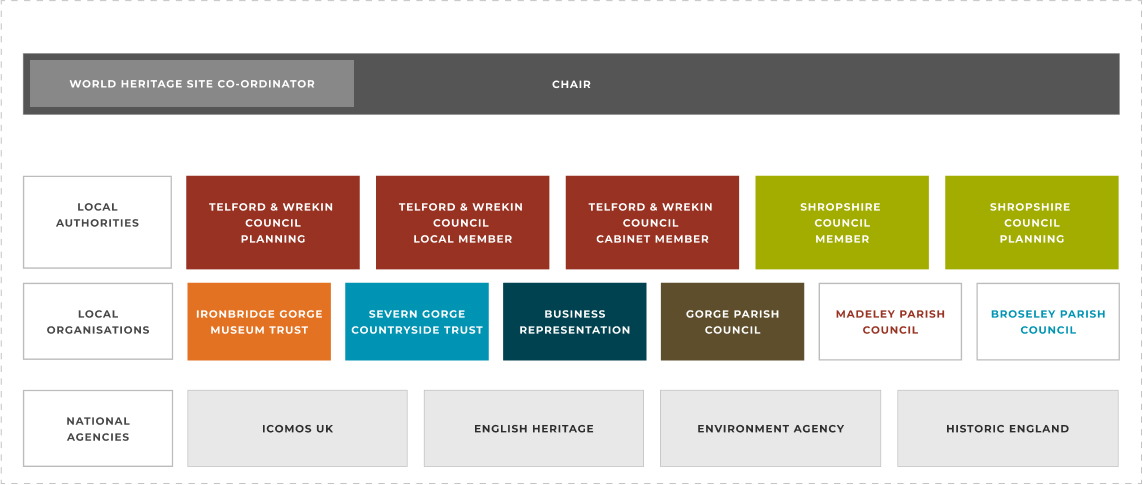
Steering group responsibilities
- Agrees a common vision and overarching strategy for the Ironbridge Gorge World Heritage Site through the regularly updated Management Plan and subsequent Action Plan.
- Communicates and advocates the agreed vision and strategy through the influencing members’ respective organisations.
- Agrees action programmes and priorities for specific aspects within the Ironbridge Gorge World Heritage Site Management Plan and monitor progress against objectives.
- Directs the development of policies and codes of practice which balance the needs of local communities with the historic and natural environment and are implemented by all responsible agencies.
- Provides regular liaison across members’ learning and community engagement activities within the Ironbridge Gorge World Heritage Site.
- Receives, invites and debates reports from professional and community groups on activities, threats and opportunities which affect the World Heritage Site.
- Provides general direction towards common goals which enhance, preserve, and conserve the Ironbridge Gorge World Heritage Site.
Steering group agendas and minutes
The Ironbridge Gorge World Heritage Site Steering Group meets four times a year. The agendas and minutes of the meetings are recorded below for public information.
View and download meeting documents below:
January
Meeting agenda → Meeting minutes →
April
Meeting agenda → Meeting minutes →
July
Meeting agenda → Meeting minutes →
October
October